Update:1/15/22 at 6:31 AM People Move To Higher Ground “Pestilence” Often Translated “Plague” or “Weather Disaster” – God’s Talking – US West Coast Under Tsunami Threat After Undersea Volcano Eruption In South Pacific – The Big Freeze is Coming
People waking up in San Diego have received a terrifying "emergency alert" on their phones warning them about a tsunami that may occur around 0750 PST. "Waves of 1 to 3 feet are possible," the alert said. Here's what one reader in Mission Beach sent us:
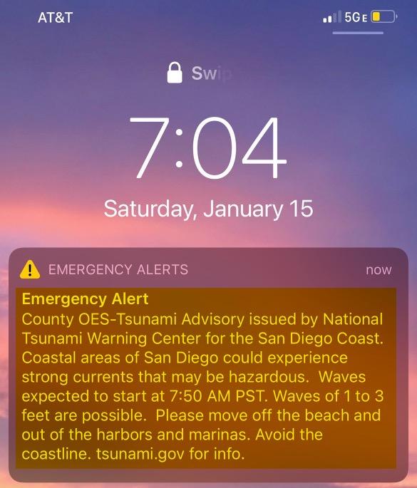
Across the West Coast of the United States, a tsunami advisory is in effect for Saturday morning. The advisories were issued after a massive undersea volcano erupted Saturday off the South Pacific island of Tonga.

"A tsunami has been confirmed and some impacts are expected," the National Weather Service's National Tsunami Warning Center said early Saturday. The advisory covers:
- The California coast from the California-Mexico border to the Oregon-California border, including San Francisco Bay.
- The Oregon coast from the Oregon-California border to the Oregon-Washington border, including the Columbia River estuary coast.
- The outer coast of Washington state from the Oregon-Washington border to Slip Point, Columbia River estuary coast, and the Juan de Fuca Strait coast.
- The north coast of British Columbia, and Haida Gwaii, the central coast and northeast Vancouver Island, the outer west coast of Vancouver Island, the Juan de Fuca Strait coast.
- The inner and outer coast of Southeast Alaska from the BC-Alaska border to Cape Fairweather, Alaska.
- South Alaska and the Alaska Peninsula: Pacific coasts from Cape Fairweather, Alaska, to Unimak Pass, Alaska.
- Aleutian Islands: Unimak Pass, Alaska, to Attu, Alaska including the Pribilof Islands.
* * *
An undersea volcanic eruption occurred 40 miles off the coast of the South Pacific country of Tonga on Saturday.

Satellite imagery shows the eruption unleashed a massive shockwave as a plume of ash was flung 12.4 miles into the atmosphere.
US Storm Watch said the eruption was the "most violent" eruption ever captured on satellite footage.
Some have compared the eruption to the "Hiroshima" nuclear bomb explosion.
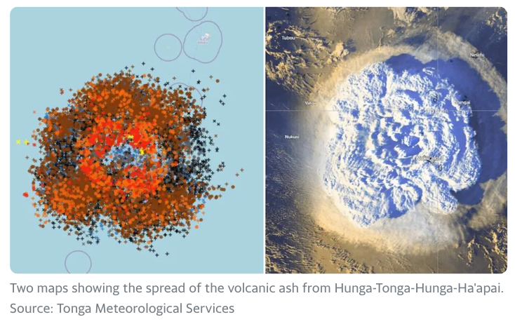
Shortly after the eruption, a tsunami warning was posted for Tonga. An advisory was issued for New Zealand's North Island. CNN affiliate Radio New Zealand (RNZ) said a tsunami hit Tonga's capital, Nuku'alofa, flooding coastal roads and properties.
RNZ said Tonga's King Tupou VI was evacuated from the Royal Palace, and residents were told to flee to higher ground.
One Tongan resident told Yahoo News the eruption was "catastrophic," and ash and rock rained down on the capital.
Twitter user Dr. Faka'iloatonga Taumoefolau posted a video showing waves coming ashore.
"Can literally hear the volcano eruption, sounds pretty violent," he wrote. In another post, he said: "Raining ash and tiny pebbles, darkness blanketing the sky."
Prof Shane Cronin, a volcanologist at the University of Auckland, told BCC this eruption is the biggest Tonga has seen in three decades.
"This is a pretty big event - it's one of the more significant eruptions of the last decade at least.
"The most remarkable thing about it is how rapidly and violently it's spread. This one was larger, a much wider lateral spread, much more ash was produced. I expect there to be many centimetres of ash that have been deposited on Tonga,' Cronin said.
“The LORD will make the pestilence cling to you until He has consumed you from the land where you are entering to possess it, Australia, China “The LORD will smite you with consumption and with fever and with inflammation and with fiery heat and with the sword and with blight and with mildew, and they will pursue you until you perish.
Plagues are also a sign, along with hostility to Christians, that we are and have been in the End Times, as Jesus Himself says:
10 Then he said to them, “Nation will rise against nation, and kingdom against kingdom. 11 There will be great earthquakes, and in various places famines and pestilences. And there will be terrors and great signs from heaven. 12 But before all this they will lay their hands on you and persecute you, delivering you up to the synagogues and prisons, and you will be brought before kings and governors for my name’s sake. 13 This will be your opportunity to bear witness. (Matthew 24)
And the Book of Revelation describes the judgments of the apocalypse in terms of pestilence and plagues:
7 When he opened the fourth seal, I heard the voice of the fourth living creature say, “Come!” 8 And I looked, and behold, a pale horse! And its rider’s name was Death, and Hades followed him. And they were given authority over a fourth of the earth, to kill with sword and with famine and with pestilence and by wild beasts of the earth. (Rev. 6:7-8)
15 Then I saw another sign in heaven, great and amazing, seven angels with seven plagues, which are the last, for with them the wrath of God is finished. (Rev 15:15)
But, along with this terrifying judgment of the Law, we also see the Gospel expressed in an Intercessor who stands between us and the plagues.

A winter storm is lining up to deliver yet more heavy snows and freezing lows to the U.S. this weekend, most notably in the Eastern half of the CONUS where long-standing cold records from the Dakotas to the Northeast are under threat.

Dangerous ice, snow and winds will makes their way through America’s Midwest, South and East over the weekend.
According to the Weather Channel, the winter storm –which they’ve named “Storm Izzy”– will move from North Dakota down to northern Georgia and then up to Maine Friday through Monday in a U-shaped track.
An “active jet stream plunging southward across two-thirds” of the United States will make its way from the Northern Plains to New England in a matter of four days, reads a portion of the report.
The National Weather Service has issued various winter storm warnings, advisories, and watches across areas of the Midwest and South. The storm could result in a significant bomb cyclone or a nor’easter hitting New York City Sunday night.
Dave Dombek, a senior meteorologist at Accuweather, told The New York Post: “A lot can change in the next few days, but given what we’re seeing right now, that’s our thinking — that there certainly will be enough snow at least for a long enough period of time that it will mess up travel … it could be a real mess for a time.”
The Weather Channel report continues: “Snow will continue to spread southeastward during [Friday] from the Northern Plains into parts of Minnesota, Iowa and eastern Nebraska. Snow could be heavy in some of those areas.
“Friday night, snow should eventually taper off in North Dakota, South Dakota and much of Minnesota, but will continue –heavy in spots– over eastern Nebraska, Iowa, northern Missouri, northeast Kansas and western Illinois.
“Rain changing to snow could spread into southern Missouri, southeast Kansas and northeast Oklahoma.”
On Saturday, the snow is expected to move south through areas of southern Missouri, southern Illinois, western Kentucky, eastern Kansas, eastern Oklahoma and northern Arkansas, with the southern Appalachians receiving “a lot of snow”.
As Saturday night comes around, “a mix of snow, sleet and freezing rain is expected to develop from parts of northern Georgia into northern South Carolina, North Carolina and southwestern Virginia,” continues the report.
The storm will then make its way from Arkansas to southern Missouri and to Kentucky and certain areas of Tennessee.
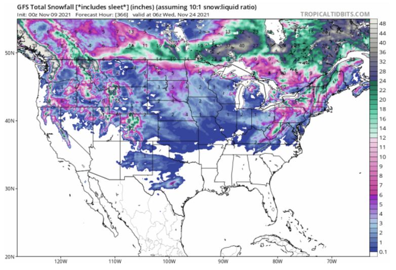
The Weather Channel notes that from Sunday on, “the uncertainty in the forecast details is still significant, dependent on the exact track of low pressure and the extent of cold air.” But adds that on Monday, parts of West Virginia, western and central Pennsylvania and New York state into New England could see the most substantial falls of the entire event, with “heavy, wind-driven snow” sweeping much of the Eastern Seaboard (confirmed by the latest GFS run below).
Already, record low temperatures are hitting the Northeast and upper Midwest. And while forecasts remain uncertain –with the jet stream almost impossible to predict nowadays– this is shaping-up to be a record-setting event.

The COLD TIMES are returning, the mid-latitudes are REFREEZING in line with historically low solar activity, cloud-nucleating Cosmic Rays, and a meridional jet stream flow (among many other forcings, including the impending release of the Beaufort Gyre).
Prepare accordingly — learn the facts, relocate if need be and grow your own.
![]()


Source: HNewsWire HNewsWire HNewsWire HNewsWire electroverse


Hulunbuir, China Suffers Coldest Day Ever (-54.4F); Seoul Registers Lowest Temp Since 1980; Big Blizzards Batter Russia And Nepal; 13 Feet Of Snow Buries Towns In Turkey; + Vancouver Sees Coldest Temp Since 1969
Hulunbuir, China Suffers Coldest Day In History (-54.4F)
Historic cold and snow has been buffeting eastern Asia in recent weeks, including the nations of China, Japan and South Korea–more on the latter below.
Following the host of Chinese locales breaking all-time low temperature records this week (which include Tuli River’s -42C (-43.6F); Fuyuan’s -42.3C (-44.1F); Wuying’s -43.3C (-45.9F); and Jiayan’s -44.4C (-47.9F)), the city of Hulunbuir has bested them all with its low of –46.9C (-54.4F) — thought to be the city’s coldest temperature ever recorded.
Hulunbuir is located in northern China’s Inner Mongolia autonomous region, and although the area is used to the cold, such a fierce and widespread chill –with much of northern China holding below -40C– has proved problematic for authorities.
As a result, major supermarkets have been instructed to increase supplies of certain necessities, and people have been urged to stay indoors, reports the South China Morning Post.
Since Dec 23, some 70 percent of China has experienced freezing temperatures, bitter winds, and snow after a severe Siberian cold wave descended deep into the country, with many locales, far more than I’ve mentioned above, enduring their lowest temperatures on record.
A meteorologist based in Beijing told the Global Times that this cold wave is “very powerful” and that it is impacting the majority of China, bringing blizzards to some parts which, in combination with the cold, are disrupting the power supply.
“The extreme weather will influence the power and energy supply in southern areas since the snow will have negative effects on the grid and the transmission of electricity,” noted one energy expert,as reported by manilatimes.net.
Seoul Registers Lowest Temp Since 1980
Much like China, over the past few days, South Korea has been hit by historic snowfall and record freezes as the accumulative effect of low solar activity accelerates the cooling of Earth’s lower atmosphere — the troposphere.
South Korea’s lowest lows have been felt in northern parts of the country, as you’d expect — Cheorwon, located in Gangwon Province, registered the country’s coldest temperature this week — the -25.4C (-13.7F).
However, the biscuit was taken by Seoul — despite the well-documented Urban Heat Island effect, which has been found to skew metropolises and built-up areas to the warm side, the nation’s capital still managed to log a legendary low of -16C (3.2F) this week — the city’s coldest December temperature in 41 years, since 1980.
And with regards to the snow, Gangwon Province has notched as much as 56cm (22 inches) in recent days, while 17cm (6.7 inches) has been registered in what is considered the warmest part of South Korea, Jeju Island.
Transport disruptions and flight cancellations have arisen across all of East Asia, particularly in Japan where they’re measuring snow totals in the feet (7+ft in Sukayu):
Big Blizzards Batter Russia…
Shifting attention east, and to the Republic of Bashkortostan, also called Bashkiria –a republic of Russia located between the Volga and the Ural Mountains in Eastern Europe– a “mad blizzard” has descended, causing traffic chaos.
As collated in the Forces Of Nature video embedded below, footage shows multiple vehicles captured by the snow in Bashkiria, where a severe blizzard has left the region struggling to cope.
A number of rescue operations are underway, according to the regional department for emergency situations, including on a section of the M-5 highway which is clogged with buses, trucks and cars due to the inclement weather.
The story is a similar one in the far northeast of Russia, in the city Murmansk, near Finland, as this video from Is it close ? shows:
…And Nepal
Headed back to the southeast, heavy snowfall and sub-zero cold has swept the landlocked South Asian country of Nepal.
A recent report from Phungling in Taplejung stated that heavy snowfall (2+feet) in recent days, particularly at elevations of 3,400 metes (11,000 feet), has led to disruptions to “normal life” and a sharp drop in the mercury.
One local, Pema Sherpa, said that people have not been able to go outdoors due to the snowfall, and that children and the elderly people have been affected the most due to the freezing cold.
13 Feet Of Snow Buries Parts Of Turkey
Turkey has been battered by intense snowfall and extreme frosts this month. Benchmarks have been falling, and people have been dying in the anomalous cold.
Particularly in eastern Turkey, and at elevations above 1,500 meters (4,900 feet), historic snowfall has managed to quite literally bury a number of locales, most notably in Muş province where persistent heavy snowfall has seen accumulations climb to more than 4 meters (13+ feet), according to local media reports.


Adem Toprak, a worker who has been involved in snow-clearing operations, told Reuters he had a hard time believing the scale of the snow depth at first, and how the accumulation could be in meters.
“We live in the city center. They said that the snow depth was around four meters here, but we didn’t believe that. We came and saw that the snow depth here exceeded four meters,” he said.
Despite reopening roads, they would soon be blocked again because of the heavy snowfall, according to local officials.
“Since the first day of snowfall, we had to reopen the roads of approximately 185 villages in our city twice,” said Seyhmus Yentur, secretary-general of Mus Special Provincial Administration. “Our fight against snow continues uninterruptedly for 24 hours with 59 construction machineries and 90 personnel,” he added.
The cold has also been noteworthy.
Low temperatures in the valleys have been approaching -40C (-40F), which is astonishing given that the records for these regions rarely descend below -30C (-22F).
Göle, for example, aptly known as ‘The Siberia of Turkey’, is currently an ice box: “We are frozen, even the water in our homes is frozen,” said local man Aleaddin Kılıç, who noted the mercury had been regularly dipping to -30C (-22F) overnight, freezing fountains, and coating trees in a thick white frost.
Eastern Turkey has become somewhat accustomed to anomalous cold and snow this month.
As have parts of the West, as the below footage (from Dec 22), shot in Istanbul, reveals:
Vancouver Sees Coldest Temp Since 1969
After Canada’s first sub -50C in December since 1998, the polar cold has persisted and spread.
Vancouverites can usually count on relatively mild winter conditions, at least compared to typical Canadian chill — but not this month: According to The Weather Network, Vancouver, B.C. reached a low -15.3C (4.5F) on Dec 27, which they described as “a radical departure from seasonal norms,” and the coldest temperature that Vancouver has seen in the past 52 years, since 1969:

The freezing weather can be credited to an Arctic outflow “funneling bitterly cold air down into southern B.C., which is then prevented from escaping”.
The fierce chill paired with Vancouver’s unusually snowy Christmas has made this a unique weather month, continues the article. But the uniqueness hasn’t just been confined to Vancouver; all of Western Canada has been holding exceptionally cold (and snowy) of late:
As has the Western U.S.:
And this extreme cold will continue dominating into the New Year, when it will then start spreading eastwards

Source: HNewsWire electroverse
ALASKA SUFFERS “PERSISTENT RECORD-SHATTERING COLD”, UNPRECEDENTED DECEMBER SNOW HITS THE PYRÉNÉES, + A FREEZING START TO WINTER IS “RAPIDLY DEPLETING” EUROPE’S GAS RESERVES
ALASKA SUFFERS “PERSISTENT RECORD-SHATTERING COLD”
North America’s ‘winter chills’ have –thus far– remained trapped in the higher latitudes where the cold has proved persistent, concentrated and record-breaking.
‘Alaska had a November to remember’, is how natureworldnews.com puts it. The town of King Salmon, for example, suffered its coldest Nov on record, averaging just -15.6C (4F), and it wasn’t alone — according to National Weather Service data, many Alaskan locales suffered either their coldest or one of their coldest Novembers in recorded history last month.
Conversely, and despite a brief burst of cold this week, the CONUS has held pretty mild all fall — the warmth has actually been record-breaking at times. But rather than pointing the finger at man’s wholly irrelevant CO2 emissions, you need to instead accept that the lower-48 has been stuck on the ‘underside’ of the jet stream in recent weeks, meaning it has been open to tropical warmth being dragged up from the south as opposed to Arctic cold being pulled down from the north.
A warmer United States in November is not an indication of global warming. The nation’s standard autumn temps weren’t heated by cow farts, nor did they up and vanish or escape into space; no, they were instead merely trapped at the higher latitudes, specifically in and around the Arctic–a region of the world which, according to the 15x NASA/NOAA AMSU satellites that measure every square inch of the lower troposphere (where us humans reside), cooled a staggering -1.05C in November (while the global average temp cooled a substantial -0.29C)
Source: electroverse
`
For we know that up to the present time all of creation groans with pain, like the pain of childbirth.
(Romans 8:22)

Winter 2020-2021 is going to be brutal.
Social Media, Google, Twitter are purging HNewsWire followers, and Fakebook are labeling HNewsWire article as “false”
D.C. SUFFERS COLDEST START TO NOVEMBER IN A DECADE
Washington D.C. has just experienced its coldest first week of November since 2012 (the year 2012 occurred a few years after the onset of solar cycle 24 — a very similar setup to today re solar cycle 25).
Last week, the average temperature in D.C. finished at a mere 48.3F — that’s more than 5 degrees below the seasonal norm.
The chill represented a jarring reversal from October, points out the washingtonpost.com, with the previous month posting an average temperature of more than 5 degrees above the norm. But rather than serving as an indication of catastrophic anthropogenic warming, this stark flip-flopping better serves as evidence of the ‘swings between extremes’ witnessed during times of low solar activity (click below for more on that):
The nights in November’s first week, in particular, stood out for being cold, dipping into the 30s five straight times between November 3 and 7 — that actually marked the longest streak with lows in the 30s in November’s first week since 2002, and not since 1962 have there been more.
Just about all of the regions of the Washington suffered at least one instance of freezing temperatures, ending the growing season. At Dulles International Airport, for example, the mercury fell below freezing five straight mornings spanning November 3 to 7, dipping as low as 28 degrees on November 6 — that equaled the most on record for the locale in November’s first week.
The WP article concludes that a “dip in the jet stream over the eastern United States … allowed the cold air to spill south”, which is accurate, but what they fail to address is the cause:
https://electroverse.net/recap-the-changing-jet-stream-and-global-cooling/embed/#?secret=UIIwvZ0oxj
VIOLENT ARCTIC PLUNGE TO ENGULF THE ENTIRE UNITED STATES
A severe blast of polar cold is preparing to drop anomalously-far south and engulf the entire United States–from coast to coast. I don’t consider the above title hyperbole — if the forecasts play out, this will prove historic.
Pockets of cold are expected as we approach this weekend, particularly for central regions; however, looking at the latest GFS 2m temperature run (shown below), the real fun is set to commence around Thursday, November 18 as an all-encompassing Arctic air mass drops down from Canada
Update:11/9/21 at 8:51 PM "Severe"
Weather observer Electroverse is forecasting a "severe blast" of Arctic air to encompass parts of the US Lower-48 beginning late next week.
Cap Allon, Electroverse's editor, wrote a note Tuesday which outlines how a possible Arctic air mass will pour into the U.S. from Canada beginning on Nov. 18.
Allon said, "a word of caution, though: this forecast is still in the unreliable time frame — the models could easily shift. But saying that, the GFS predicting such a widespread blast of cold and with such confidence, too, does lead me to believe that this, or something similar, is indeed about to play out — and if it does, cold-records will be threatened across almost every state."
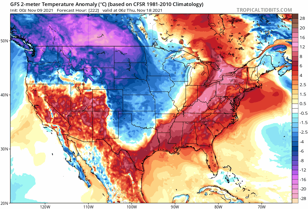
GFS models also predict heavy snow for some parts of the country through Thanksgiving.
Colder weather could complicate things for some power plants transitioning to coal from natural gas because of high prices. The ability to source coal this winter has become extremely hard.
Last month, Ernie Thrasher, CEO of Xcoal Energy & Resources, the largest U.S. exporter of fuel, said demand for coal will remain robust well into 2022. He warned about domestic supply constraints and power companies already "discussing possible grid blackouts this winter."
A pure-play on cold weather and heightened coal demand is Peabody Energy, the largest coal company globally, which has seen earnings triple amid the global energy crunch.

So if forecasts are right about next week, expect colder weather and soaring energy costs. In the meantime, the green transition will be placed on hold this fall/winter (in terms of the percentage of power generation on the grid) as the world returns to coal. Source: ZeroHedge
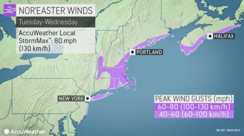
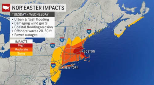
Update:10/25/21 at 8:51 FM God's Talking: The Next "Bomb Cyclone" Could Unfold Over New York City
Just as the bomb cyclone and atmospheric river dumped record amounts of rain across Northern California, there are new reports of a nor'easter forming off the Atlantic coast and could rapidly strengthen into a bomb cyclone.
The nor'easter is strengthening as it traverses the Eastern Seaboard but is expected to lose momentum and become stationary off the Northeast coast late Monday evening.
Meteorologist Ryan Maue tweeted that "the potential for a very powerful Nor'easter is increasing for Tues/Wed." He said, "the track the developing Low Pressure will determine if / where hurricane-force wind gusts impact the coast including Boston."
Maue warned: "Yes, this is a major bomb cyclone."
⚠️The potential for a very powerful Nor'easter is increasing for Tues/Wed of upcoming week.
The track of the developing Low Pressure will determine if / where hurricane force wind gusts impact the coast including Boston.
Yes, this is a major bomb cyclone. pic.twitter.com/3qkW9GPfBo— Ryan (@RyanMaue) October 24, 2021
Accuweather weather models show coastal areas from New Jersey to Boston will be heavily impacted by the storm.
"An early season tempest could bring a wind-driven, chilly rain to portions of the Northeast from Monday through Wednesday," AccuWeather Meteorologist Randy Adkins said, adding that flooding could be a significant concern.
New York City is bracing for torrential rain and high winds Monday evening. The storm will then move up into central and southern New England, where it will continue dumping rain on Tuesday.
It will be a stormy Tuesday night from Boston to Portland, Maine.
New York City could expect upwards of 4 to 8 inches. Possible flooding conditions could be seen. Residents are bracing for the nor'easter after a deadly storm killed more than 40 people across the metro and greater area earlier this year.
Between Tuesday and Wednesday, peak winds could be Category 1 hurricane strength.
Much of the impact from the storm will be between New York City and the Boston area.
Two bomb cyclones within days terrorizing US coasts? Time for Swedish climate alarmist Greta Thunberg to unleash a tweet barrage at the Biden administration for not doing enough to quell climate change. Source: ZeroHedge HNewsWire
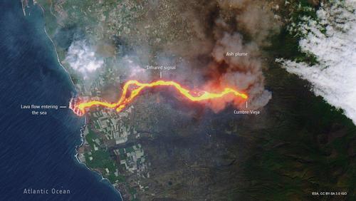
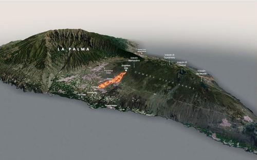
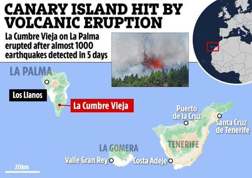
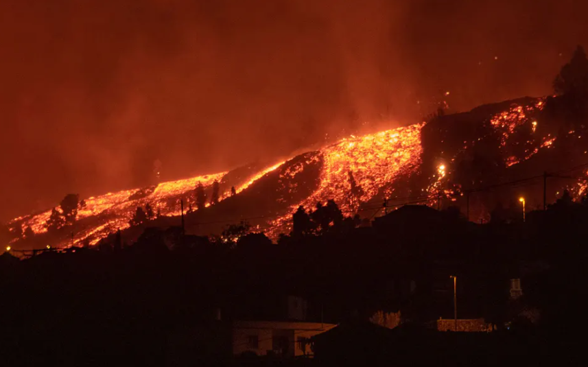
Update:10/2/21 at 5:51 AM "Biggest Tragedy Ahead Of Us" - New Lava Blast Detected At Canary Islands Volcano
The Canary Islands' Cumbre Vieja volcano increased its eruptive force on Friday as a new fissure opened up.
Spanish Geological and Mining Institute (IGME) said two new lava flows had emerged from a third fissure approximately 400 meters from the main crater.
At least three vents have opened since the volcano erupted on Sept. 19, but the latest one is being closely 'monitored.'
Volcán #CumbreVieja, en intensa actividad
La ceniza expulsada cubre ya una superficie de 3.304 hectáreas en #LaPalma.
Con las dos nuevas bocas, son ya cuatro los centros emisores de lava. El volcán entró en erupción el pasado 19 de septiembre.#DWNoticias /cmw pic.twitter.com/Qv24qb1Pfd— DW Español (@dw_espanol) October 2, 2021
🔴Dantesco paisaje!!#ElVolcanDeLaPalma#LaPalma#LaPalmaEruption#CumbreVieja#Volcano pic.twitter.com/s8VUT27Ysi— Life (@JavierApophis) October 2, 2021
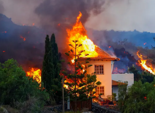
More than 6,000 people have been evacuated. Lava flows have destroyed 1,000 building structures, and Spain has approved a $12.2 million aid package to help the island.
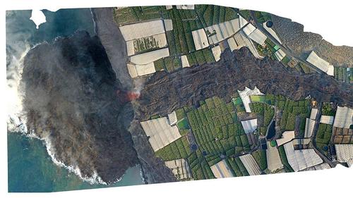
Satellite imagery captured by the European Space Agency shows the trail of destruction:
A closer view of the lava meeting the ocean.
On Friday, the regional leader of the Canary Islands, Ángel Victor Torres, told reporters during a scheduled press conference that Cumbre Vieja has released an astonishing 80 million cubic meters of lava, or more than double the amount than the last eruption in 1971.
"We have the biggest tragedy ahead of us, more people we have to help," Mariano Hernández Zapata, the president of the island council of La Palma, told El País. "We are worried about the course this new flow of lava could follow, although we hope that it will join the other."
Minister Felix Bolanos visited the island on Friday to reassure locals the Spanish government would support them in this time of need:
"We are all clear about what is the priority: helping the citizens of La Palma. Residents must be calm and proud of their institutions," Bolaños.
A new fissure emerging is not a positive sign that the eruption is abating anytime soon. Earlier this week, the volcano entered a 'new explosive phase.' There's also the threat of toxic gases poisoning the air as the lava meets the ocean. Even in Europe, there have been reports of acid rain. Source: ZeroHedge
USGS Warns Hawaii's Kilauea Volcano Erupting In "Full Swing"
Update: 9/30/21 at 5:21 AM The U.S. Geological Survey (USGS) confirmed that Hawaii's Kīlauea volcano began erupting Wednesday after a swarm of earthquakes.
Kīlauea is one of the most active volcanos on Earth and "was once a cooling lava lake is now a new fissure eruption," USGS Volcanoes tweeted.
Before..and..After! #Kilauea #volcano summit #eruption is in full swing. What was once a cooling lava lake is now a new fissure eruption! https://t.co/ZIxSFKk70V
Follow along with updates at the #HawaiianVolcanoObservatory website. #HVO https://t.co/KGKIwXB2A8#KilaueaErupts pic.twitter.com/jCqTFsJRMS— USGS Volcanoes🌋 (@USGSVolcanoes) September 30, 2021
USGS detected the eruption around 1520 local time at Kīlauea's summit crater. The agency raised the volcano's alert system "WATCH" to "WARNING" and its aviation color code from "ORANGE" to "RED" by evening.
#Fissures of #lava and falling of #tephra!
A line of low lava fountains is erupting from the crater floor, tephra is falling downwind, and a new fissure opened up on the west wall of Halemaʻumaʻu crater. https://t.co/jDxUTFInn4 #KilaueaErupts pic.twitter.com/ONcGrmutua— USGS Volcanoes🌋 (@USGSVolcanoes) September 30, 2021
"All signs indicate that it will stay within the crater," Ken Hon, the top USGS volcanologists at Hawaii Volcano Observatory, told ABC. "We're not seeing any indications that lava is moving into the lower part of the east rift zone where people live. Currently, all the activity is within the park."
According to the USGS website, the latest alert level suggests an eruption is "imminent, underway or suspected," according to the USGS website.
The Sun has set on the new eruption within Halemaʻumaʻu crater at Kīlauea’s summit. We’ll be back in the early morning with more posts here, but in the meantime, new images and other info will be posted throughout the night at https://t.co/Lm77CMQ2Tc. #KilaueaErupts #kilauea pic.twitter.com/olCDWes1F7— USGS Volcanoes🌋 (@USGSVolcanoes) September 30, 2021
Kīlauea's most recent eruption was around December of last year. Residents in the area were asked to remain indoors to avoid toxic gasses and ash clouds. A few years before that, in 2018, another eruption was more powerful and destroyed hundreds of homes and forced many residents to evacuate.
Volcanologists still don't know if magma has filled reservoirs within Kīlauea, which would repressurize the volcano and result in a much larger eruption.
Source: ZeroHedge
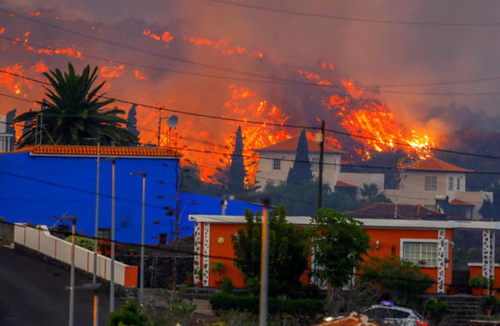
Canary Island Residents Told To "Stay Inside" After Toxic Cloud Emitted As Lava Reaches Sea
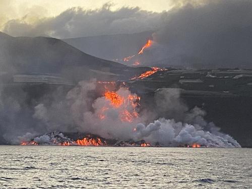
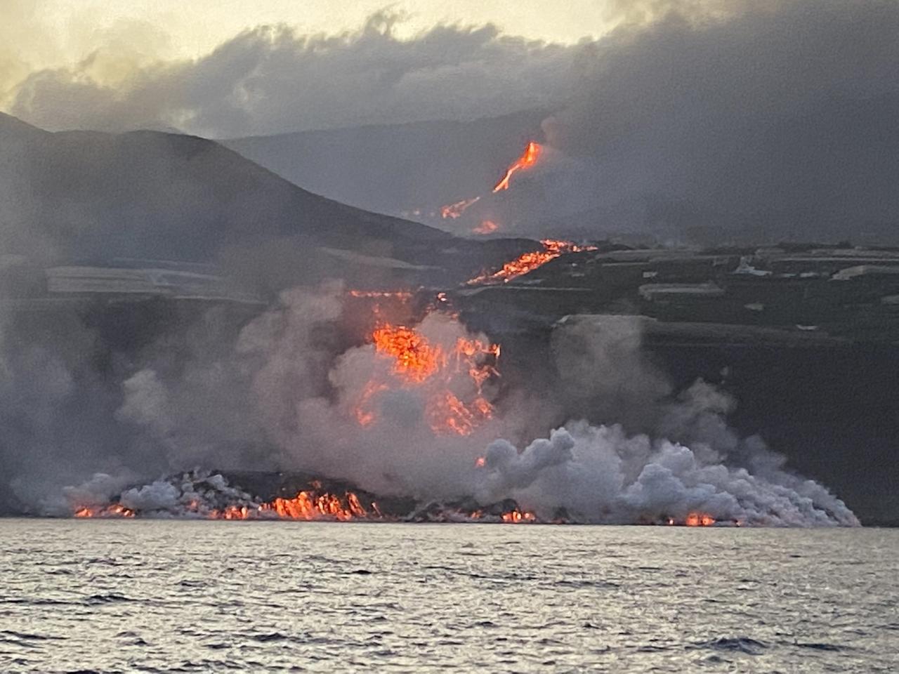
Update: 9/29/21 at 5:21 PM Nine days after the volcanic eruption on the Spanish island of La Palma, officials have warned residents to hunker down inside their homes due to toxic gases emitted from the lava.
Lava over 1,800 degrees Fahrenheit from the Cumbre Vieja volcano is pouring into the Atlantic and creating a dangerous chemical reaction emitting steam, toxic gas (including hydrochloric acid), and tiny shards of volcanic glass into the atmosphere.
Monitoreo del primer contacto de la lava con el medio marino. Buque oceanográfico #RamonMargalef @IEOoceanografia @CSIC pic.twitter.com/g3fiKsIA6E— Eugenio Fraile (@EugenioFraile) September 29, 2021
Amanece en La Palma y comienza a formarse un delta de lava que poco a poco gana terreno al mar. pic.twitter.com/KNg6jy5Y4K— Instituto Español de Oceanografía (@IEOoceanografia) September 29, 2021
Authorities warned residents within a two-mile range of where the lava meets the ocean to stay indoors and duct tape windows and doors to ensure that toxic gases don't come inside.
Sky's Becky Cotterill said the wind was blowing the toxic gases into the ocean on Wednesday, but fears conditions could quickly change.
"The lava has been slow-moving and changing course, but at 11pm last night it did finally drop off a cliff about a hundred feet high into the sea, creating what essentially looked like a lava waterfall.
"Scientists were really concerned about that because when lava hits the water it creates a thermal shock.
"That shock releases toxic gases that contain hydrochloric acid and it's very dangerous to breathe in and also dangerous if it gets in your eyes or on your skin.
"Residents in the surrounding areas have been told to stay inside," Cotterill said.
More than 6,000 people have had to evacuate, and at least 400 homes have been destroyed since the Sept. 19 eruption. The volcano continues to emit large columns of smoke that have produced ashfall across the island and acid rain in southern parts of Europe. Source: ZeroHedge
Acid Rain From Canary Islands Volcano To Reach Europe
Acid rain caused by sulfur dioxide gas spewing from the volcano in Spain's Canary Islands of La Palma will reach Europe this weekend.
9/25/21 at 3:21 AM Lava flows from the Cumbre Vieja volcano is releasing thousands of tons of sulfur dioxide gas into the atmosphere, and mixing with clouds will fall downwind towards France and the Mediterranean basin.
Les concentrations en SO2 issues de l'éruption du volcan aux #Canaries vont augmenter sur le bassin méditerranéen et en France durant le week-end, sous l'effet d'un flux de sud-ouest.
Elles seront surtout sensibles entre 1000 et 3000 m d'altitude. Modèle CAMS @CopernicusEU https://t.co/w1mleirm56 pic.twitter.com/Yj3E4iAQLx— Keraunos (@KeraunosObs) September 23, 2021
The volcanic eruption emits between 7,997 and 10,665 tons of sulfur dioxide per day and may last between one and three months. Areas downwind are at risk of acid rain, posing health issues for humans and animals by aggravating pre-existing respiratory illnesses. There's also the risk it may damage crops and contaminate drinking water.
Fire and Brimstone (Sulfur) raining down from heaven?
❗️La Palma volcano eruptions spread Sulphur Dioxide over parts of North Africa and will reach Europe within the day
Holidaymakers have been urged to take cover from acid rain by meteorologists!https://t.co/bd8ZjjPpx4 pic.twitter.com/khVjWKs4QT— Wide Awake in Switzerland (@timetowakeupsw1) September 22, 2021
The latest activity of Cumbre Vieja this week was a new fissure that emerged on Monday and produced additional lava flows that resulted in 500 islanders evacuating.
Volcanologists expect Cumbre Vieja to continue producing similar behavior in the coming days and weeks, which means Europe might receive additional rounds of acid rain. Once the pressure in the magma chamber goes down, lava will stop flowing. Source: ZeroHedge HNewsWire
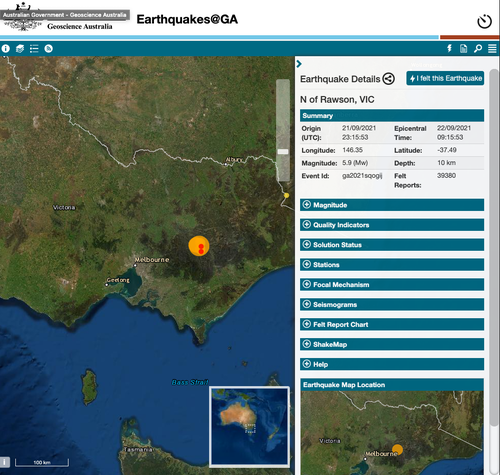
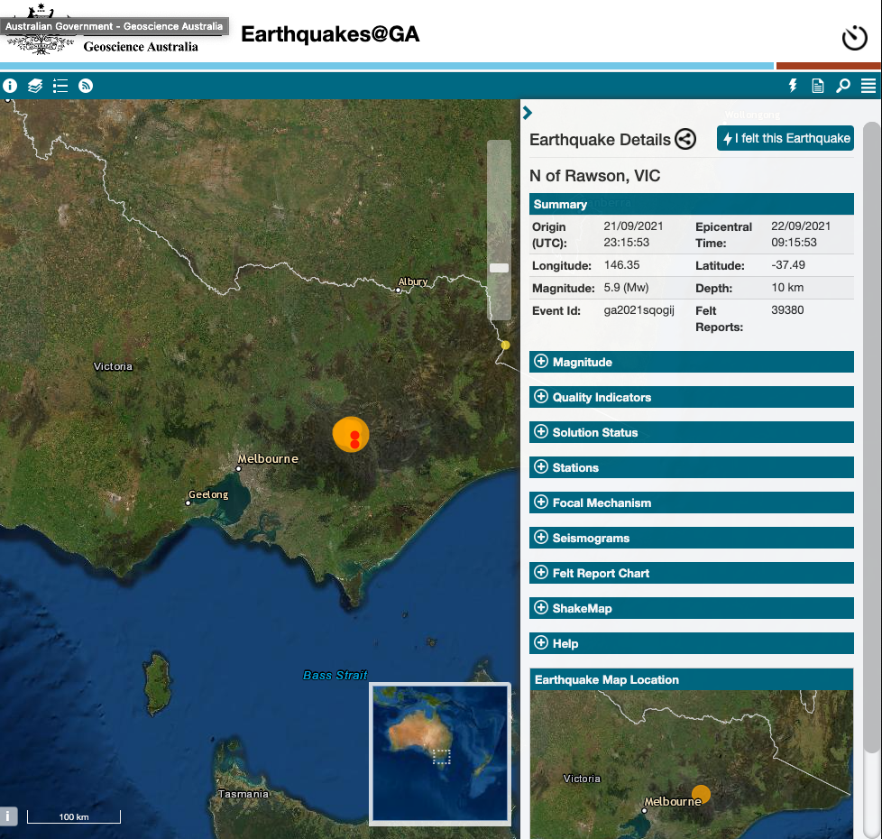
"Very Rare" Earthquake Rocks Melbourne, Buildings Shake Across Australia
Update: 9/22/21 One of the most powerful onshore earthquakes that rocked the state of Victoria, Australia, couldn't have come at the worst time as anti-lockdown protesters are fed up with the government's COVID restrictions and vaccine requirements.
According to Geoscience Australia, a magnitude 5.9 earthquake struck around 0915 local time about 75 miles northeast of Melbourne, causing damage to buildings.
Photos and videos flooded social media of the aftermath. It appears some buildings in Melbourne were damaged. So far, local officials are reporting no casualties.
This collapse says more about the building stock in Melbourne than the size of the earthquake. Lucky the earthquake occurred during lockdown - another win for @DanielAndrewsMP perhaps? pic.twitter.com/azhn8bWW8s— Dan Jaksa on Geoscience 🌏🌔 🗺📡🛰 🌊🌋 (@Danksa) September 22, 2021
A magnitude 5.8 earthquake — Australia’s biggest in 5 years — has caused damage in Melbourne.
The quake was at a depth of 10 km (6 miles) https://t.co/cG3lcATWKB pic.twitter.com/kSL9IHURE3— Bloomberg Quicktake (@Quicktake) September 22, 2021
Building damage in melbourne after the earthquake pic.twitter.com/jKglIxIB6I— B || A Man That Can Do Both (@Brodhe) September 21, 2021
Australian Prime Minister Scott Morrison updated the press on the ongoing situation and said quakes are "very rare events in Australia." Several tremors were felt after the initial quake.
CORRECTION: A magnitude 6.0 earthquake struck near Melbourne, causing damage to buildings in the country's second-largest city and sending tremors throughout neighboring states https://t.co/mrMSYLSSzB We are deleting a previous video to correct a courtesy pic.twitter.com/MRiJe1QsVG— Reuters (@Reuters) September 22, 2021
The timing of the quake comes as people in Melbourne are under COVID lockdowns. On Tuesday, more than 20,000 anti-lockdown protesters clashed with police and shut down city streets.
Dee Ninis at the Seismology Research Centre in Melbourne said the metro area should be thankful the epicenter of the quake occurred outside town, which was not in a populated place. Source: ZeroHedge

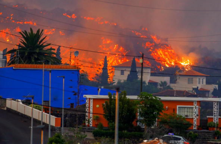
5,000 Evacuated As Canary Islands Volcano Eruption Worsens
Update: 9/20/21 at 4:21 AM The Canary Islands' first volcanic eruption since the 1970s has resulted in the evacuation of 5,000 people and more than 100 destroyed building structures.
The Volcanological Institute of the Canary Islands (Involcan) said lava flows from a sparsely populated area of La Palma are moving at 2,300 feet per hour.
El #volcán de #CumbreVieja, en la isla de #LaPalma (#Canarias) ha erupcionado y lleva desde el día de ayer expulsando lava y devastando a su paso casas, tierras agrícolas y ganaderas. Toda nuestra fuerza y ánimo a las personas afectadas. Estamos con ustedes!!!#desastresnaturales pic.twitter.com/w9e24ZNpYs— Ong Balanced World (@OngBalanced) September 20, 2021
🇪🇸🌋🏝️ #LaPalma | #Erupción | #CumbreVieja
El volcán Cumbre Vieja de La Palma entró en erupción
El Cumbre Vieja se encontraba bajo un elevado nivel de alerta desde hace una semana debido a un incremento de la actividad sísmica en la isla.https://t.co/5FDUVwd10F pic.twitter.com/lnnZXkFiw2— Diario HOY (@diariohoynet) September 20, 2021
🌋🛑 Espectáculo de la naturaleza y tragedia para muchas familias que lo están perdiendo todo. Esta tarde en @cuatroaldia la #ErupcionenLaPalma como nunca antes se ha visto #CumbreVieja @cuatro pic.twitter.com/RTYvaWUUZC— Alejandro Rodríguez (@alejandrogueztv) September 20, 2021
Here are stunning pictures of the lava flow.

"The lava is moving towards the coast, and the damage will be material. According to experts, there are about 17-20 million cubic meters of lava," regional president Angel Victor Torres told Cadena Ser radio.
Volcanologist Vicente Soler of Spain's Higher Council said, "the material appears to be very fluid; the lava flows will reach the sea sooner or later."
The lava flows are protruding out of two fissures of Cumbre Vieja, which belongs to a series of volcanoes that last had a major eruption in 1971 for several weeks. Experts said the current eruption could last for weeks or even months.
After thousands of small earthquakes were reported, La Palma had been on high alert for more than a week. Then on Sunday, another swarm of small earthquakes shook part of the island before the eruption.
By Monday morning, Spain's Civil Guard said more than 5,000 people had been evacuated. There's the possibility up to 10,000 residents, and some tourist will need to be evacuated if conditions worsened.
So far, there have been no visibility problems with surrounding airspace, and planes are operating normally across the island chain. Local airline Binter canceled flights earlier but resumed service later on Monday. Source: ZeroHedge
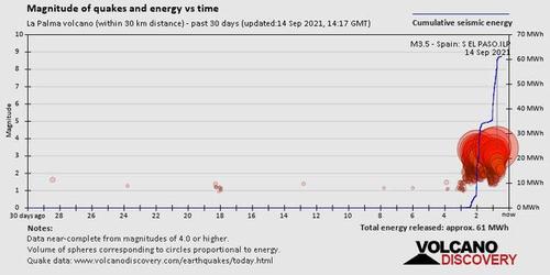
9/15/21 at 7:21 AM A Swarm Of 700 Earthquakes Rattles Canary Islands, Sparks Speculation Of Volcanic Eruption
A massive earthquake swarm has been reported around the volcanic island of La Palma in the Canary Islands of Spain. The Volcanological Institute of the Canary Islands (Involcan) said there's reason to believe the seismic swarm is due to magma slowly rising.

Involcan recorded more than 700 small earthquakes on La Palma near Cumbre Vieja volcano since last Saturday.
The largest rumble, a 3.4 on the Richter scale, was reported by Involcan on Tuesday morning. Most quakes are shallow and happen 5 to 7.4 miles down, suggesting that new magma is rising.

"Without a doubt, the current seismic swarm represents a significant change in the activity of the Cumbre Vieja volcano and is related to a process of magmatic intrusion under the island of La Palma," Involcan warned.
According to The Sun, the Special Plan for Civil Protection and Attention to Volcanic Risk Emergencies (PEVOLCA) was activated due to the increased seismic activity.
For clues about a possible eruption. Local officials reported a sensor at the volcano took a reading of the "highest Helium-3 levels in 30-years." The gas is considered a message from the mantel and may suggest future volcanic activity.
Cumbre Vieja volcano last erupted in 1971, considered one of the most active volcanoes of the Canary Islands. There have been fears an eruption could cause a megatsunami. Steven Ward first explained this theory in research from the Institute of Geophysics and Planetary Physics, University of California, Santa Cruz, California, two decades ago.
The situation warrants close monitoring due to the possibility of volcanic activity.
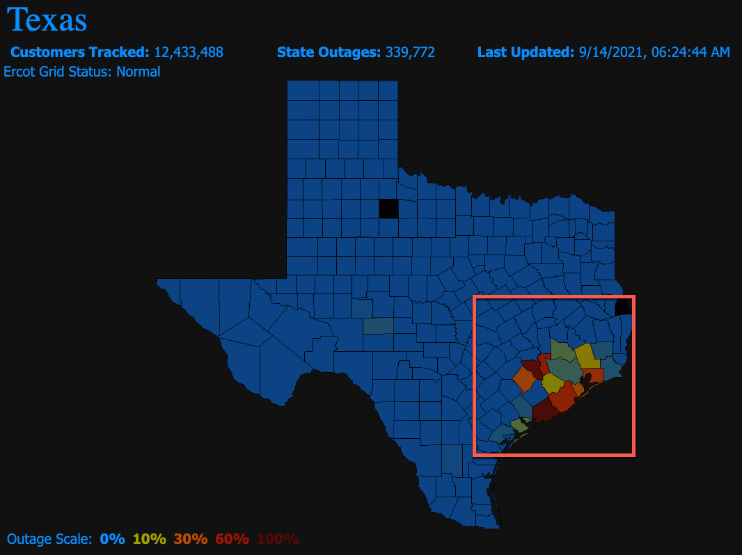
Update: 9/14/21 Cat 1 Hurricane Nicholas Makes Landfall On Texas Coast, Multiple Nuclear Power Plants In Path
Hurricane Nicholas made landfall early Tuesday morning on the Matagorda Peninsula just south of Houston, Texas. Nicholas hit the area as a Category 1 but has since been downgraded to a tropical storm with maximum sustained winds of 70 mph. Oil refiners, chemical makers, grain exporters, and even multiple nuclear power plants are in its path.
Ahead of Nicholas' arrival, two major oil export terminals either suspended or restricted vessel traffic. Port authorities in Corpus Christi halted inbound sailing; Ports in Houston and other surrounding areas restricted vessel traffic. Preparations for the storm included oil companies evacuating offshore oil/gas platforms and hunkering down land-based operations.
What's on our radar this morning is the storm passing over the nuclear power station southwest of Bay City, Texas, about 90 miles southwest of Houston. The 12,200-acre site is home to South Texas Project Electric Generating Station. The storm is forecasted to arrive in oil and gas heavy Houston around 1800 local time.
At the moment, about 340,000 customers are without power in Southeast Texas.
Storm impacts and energy outages could be problematic for COVID hotspots.

Nicholas emerged on our radar last Friday as a tropical wave over Honduras, the western Caribbean Sea, and has since organized and strengthened into a hurricane and now downgraded to a tropical storm.
The National Hurricane Center (NHC) expects storm surges of 2 to 5 feet and up to 18 inches of rain in some areas over southeast Texas. Some of these areas are crammed with industrial facilities, and even coastal neighborhoods could be prone to flooding. One area to watch for flooding is Houston:
"Houston is in the crosshairs," Steve Silver, a senior meteorologist with Maxar, noting that precipitation poses a bigger threat than wind, told Bloomberg. Nicholas will be "a significant rainfall event."
The storm's timing is precarious for the oil/gas industry that has been crushed by Hurricane Ida, hitting neighboring Louisiana two weeks ago. Oil-refining and offshore drilling have been paralyzed in the wake of the storm. Making matters worse, Nicholas could make its way to Louisana by early Wednesday into late Thursday.
Currently, 44% of U.S. Gulf crude production is offline, while 52% of the region's gas output is down. This has put a bid under natgas and crude prices.

"Investors were worried that Nicholas would cause further disruption in the Gulf Coast at a time when they were trying to figure out how long crude output would stay affected from Ida," said Satoru Yoshida, a commodity analyst at Rakuten Securities.
The International Energy Agency said losses from Hurricane Ida have wiped out increases from OPEC+. The organization said additional supplies would come online in October.
NYC Paralyzed, 9 Dead As Ida Remnants Unleash "Once In A Century Storm" Across Northeast
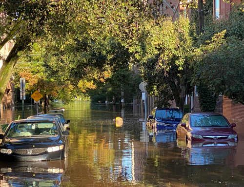
Update: 9/2/21 at 10:21 AM, Well, it's the morning after one of the worst floods in possibly a century for parts of the Northeast.
NJ.Com's Noah Cohen tweeted images of floodwaters nearly cresting bridges in Philadelphia.


A street in Yonkers, a city on the Hudson River, is entirely underwater.
Nepperhan Ave in #Yonkers is underwater @News12WC @News12HV #floods #NYFloods pic.twitter.com/loVf4kibBH— Nadia Galindo (@NadiaGalindoTV) September 2, 2021
Floodwaters in Rye, New York.
😔 CAR ON TOP OF CAR • RYE, NY • 7AM THURSDAY 9-2-2021
As flood waters recede, we are left with images like this. 🙏
📷: @ tommckev/IG pic.twitter.com/tJGydej8Fx— Matt Hammer (@MattHammer12) September 2, 2021
Flash floods in Portsmouth, Rhode Island, destroyed streets.
“It looks like when you cut into a brownie and it all crumbles down … It just is unbelievable to think that this is a road.”#BREAKING
— @KaitLouiseWalsh reports on flood-damaged road in Portsmouth, Rhode Island, in the wake of Hurricane Ida. pic.twitter.com/2SkN4vwcgv— Büyük Türk Haber Son dakika 🇹🇷 (@BuyukTurkHaber) September 2, 2021
Expect more updates on damage throughout the day.
* * *
The remnants of Hurricane Ida triggered Flash Flood Emergencies for New York City and New Jersey late Wednesday night as torrential rain, winds, and tornados unleashed chaos across the Northeast, effectively paralyzing New York where subways were flooded and where mass transit remains largely halted. Reuters reports at least nine weather-related deaths from flash flooding in NYC and New Jersey. The deadly waters swamped subway stations, airport terminals, highways, tunnels, and baseball stadiums.
Here are some of the most recent developments courtesy of Bloomberg:
- Travel Advisory in Effect on NYC Streets: 7:30 a.m. A travel advisory remains in effect in New York City, which asked all non-emergency vehicles to stay off the city’s streets and highways while clean-up continues. The city had lifted a ban on non-essential travel at 5 a.m.
- Biden to Speak About Federal Response to Ida: 7:26 a.m. President Joe Biden is scheduled to deliver remarks from the White House at 11:30 a.m. on the federal response to Hurricane Ida, which cut off power for millions and prompted gasoline shortages affecting millions of people across Louisiana. Biden plans to visit Louisiana on Friday to survey storm damage and assess the federal response.
- MTA Service ‘Largely Suspended’ in NYC: 6:56 a.m. New York’s Metropolitan Transportation Authority service on subway, bus and commuter rails is “largely suspended due to heavy rainfall and flooding across the region,” according to the MTA’s website. The C, E, B, Z, S and Number 3 lines were among those suspended as of 7:30 a.m. Other lines had significant delays.
Around 2340 ET Wednesday, we posted a weather note detailing the mayhem in NYC as flash floods in subways and multiple tornadoes through New Jersey, caused both states and NYC Mayor Bill de Blasio to declare a state of emergencies.
New York City subway station flooded with water very dangerous pic.twitter.com/aYBNVGUpUb— Movie Reviews By JT (@moviere09350416) September 2, 2021
Bushwick floods.
Knickerbocker Avenue.
Stay safe! pic.twitter.com/055vYjSgCK— thisbushwicklife (@BushwickLife) September 2, 2021
Costco on Staten Island! pic.twitter.com/gUYVw8tBBN— Mikey Cee (@MikeyCee24) September 2, 2021
doesn't need location, it's just: new york pic.twitter.com/osdAxN7CtF— Christiaan Triebert (@trbrtc) September 2, 2021
The River Walk is absolutely submerged pic.twitter.com/HCH4x3SXJf— Taryn Hatcher (@TarynNBCS) September 2, 2021
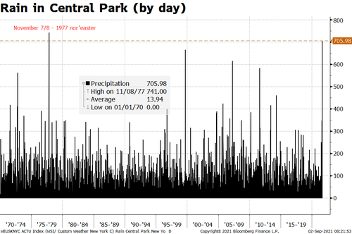
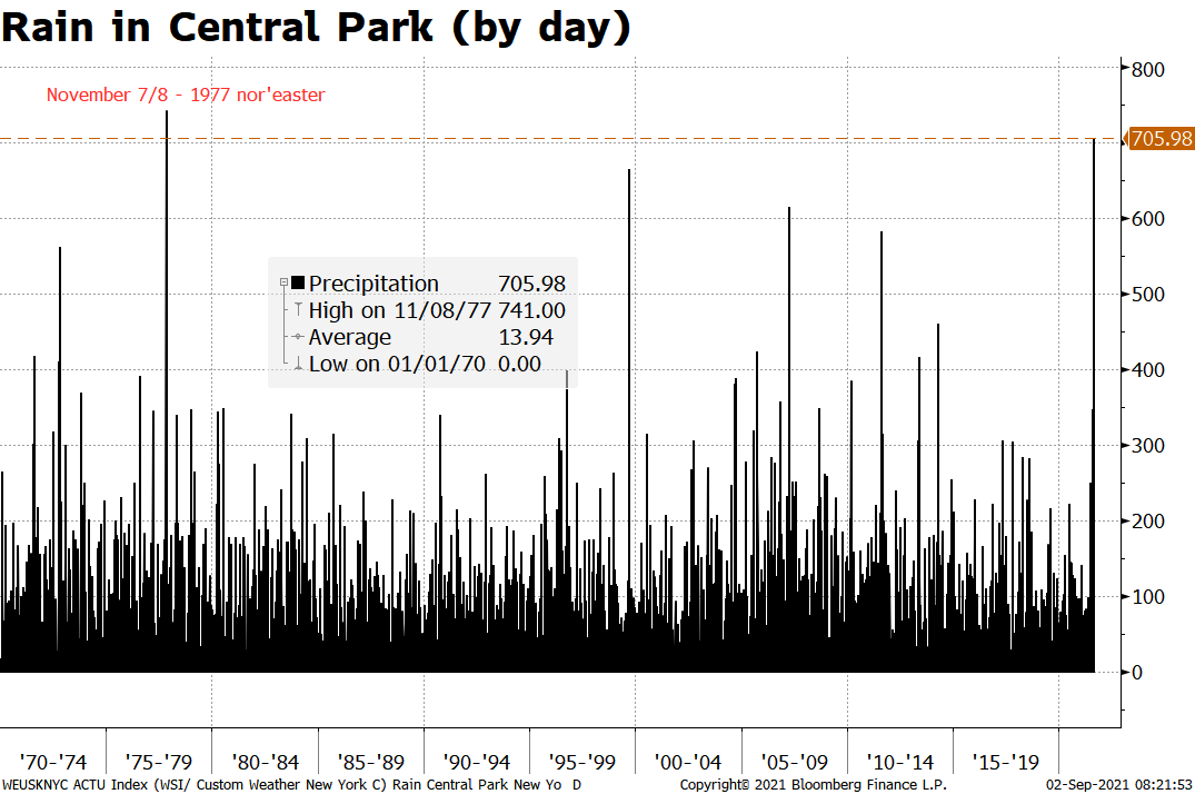
The expected rainfall rate in NYC was an astonishing 3 to 5 inches per hour. The National Weather Service (NWS) issued a Flash Flood Emergency that warned residents of the metro area to "Seek higher ground now!"
Between 2051 ET and 2251 ET, remnants of Ida dumped 3.15 inches in Central Park. To put that in perspective, that's about seven weeks of average rainfall in about an hour, NWS meteorologist Alex Lamers told Bloomberg.
Northeast 24-Hour Rain Map
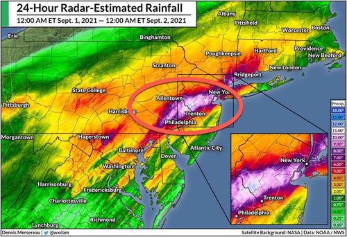
NYC's subway system was paralyzed as water from the streets poured onto underground train platforms in Manhattan. In New Jersey, nearly all of NJ Transit's rail service was suspended.
New York Gov. Kathy Hochul declared a state of emergency late Thursday — directly after NYC Mayor Bill de Blasio announced his, along with a travel ban for all non-emergency vehicles through 0500 ET.
According to Axios, NWS discussions and other meteorologists have suggested yesterday's storm was a one in 100- to 500-year event.
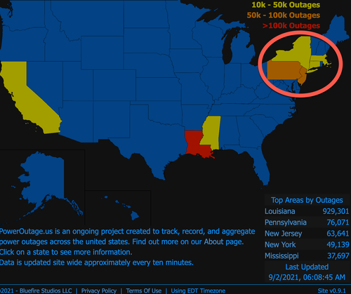
Between Pennsylvania, New Jersey, and New York, Poweroutage.US indicates approximately 200,000 people are without power on Thursday morning.
Earlier Wednesday, multiple large tornadoes were spotted in Maryland, Pennsylvania, and New Jersey, causing damage.
Apparent tornado near N.J. Turnpike earlier tonight #Ida pic.twitter.com/VTtnJBrkY9— David Begnaud (@DavidBegnaud) September 2, 2021
Tornado rips through Mullica Hill NJ, just devastating pic.twitter.com/mE3j6B0kCj— Anna McAllister (@annamactv) September 1, 2021
Footage of the Annapolis MD tornado is nuts. You don't see tornadoes this destructive on the east coast all that often.
Footage posted by Melanie Newmanpic.twitter.com/xLjaiOSwZu— Doc V (@MJVentrice) September 1, 2021
"Get in the bathtub now!"
Listen as the winds howl in a powerful, #tornado warned storm in Pennsylvania. Talk about a close encounter.
Remember, the safest place during a tornado is the lowest level, most interior room. Away from doors and windows. pic.twitter.com/gpGT8lJjSj— WeatherNation (@WeatherNation) September 2, 2021
... and, of course, climate expert Greta Thurnberg was busy tweeting away last night about the chaos in the Northeast, seizing any opportunity to push her climate change agenda, because clearly this was the very first hurricane to hit the Tristate area since the Ice Age. Source: zerohedge
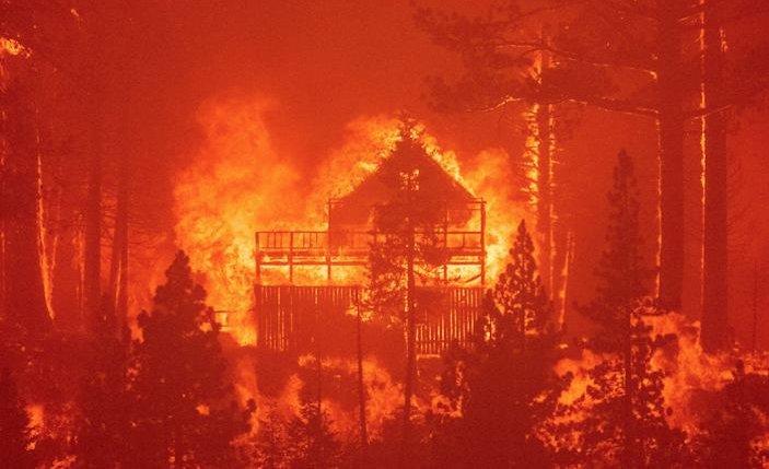
50,000 People Evacuated As Firepocalypse Ravages South Lake Tahoe
Update: 9/1/21
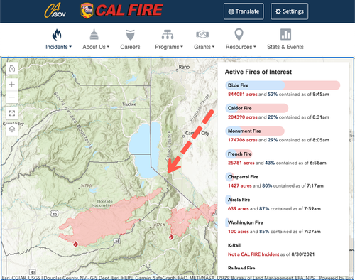
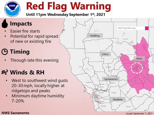
By the day, the fire situation on the ground of South Lake Tahoe continues to worsen, with more than 200,000 acres burned, 50,000 people evacuated, and a red flag warning that remains in effect for a swath of eastern California.
According to the California Department of Forestry and Fire Protection, otherwise known as CAL Fire, the Caldor Fire has burned 204,390 acres as of Wednesday morning and is only 20% contained. The fire is rapidly expanding because of favorable weather conditions, such as low humidity, hot temperatures, and winds.
Evacuation orders for all residents in the South Lake Tahoe area began on Tuesday, and so far, 50,000 people have been relocated. Winds are expected to pick up Wednesday, adding more fuel to the fire as a red flag warning is in effect until Wednesday night.
Military planes have been tracking the fire and guiding firefighters to hotspots hidden underneath the dense smoke.
"Very, very sensitive sensors can pick up any signature of heat," said Joel Kerley, a Department of the Interior bureau aviation manager. "We'll plot it, we'll get that down to the firefighter on the ground, and they can go attack it."
We showed yesterday probably the most shocking video from what is now being dubbed 'Lake Tahell.'
This video from Lake Tahoe is insane pic.twitter.com/9nZGJdwK42— Angelina Martin (@angewrites) August 29, 2021
Evacuee Glen Naasz told CBS News that he's "afraid" the fire will "burn down the jewel of California," referring to the Lake Tahoe area.
The Sacramento Bee said the fire threatens 34,000 homes and buildings around Lake Tahoe. Gov. Gavin Newsom has said it's the state's "No. 1 priority" to extinguish the blaze.

At least 4,000 firefighters and 1,000 National Guard members are battling the fire though Mother Nature has yet to offer any signs of relief.
The Caldor Fire burning near some structures on the California side in Echo Summit. #laketahoe #caldorfire pic.twitter.com/3CaqhYyCdW— Mick Akers (@mickakers) September 1, 2021
Another large wildfire burning in the state is the Dixie Fire, which has already scorched 844,000 acres across five counties and is a little more than half contained.
The silver lining is that the fire will wipe out chipmunks infected with the plague. Source: ZeroHedge
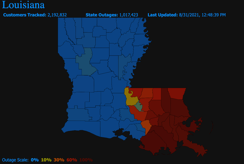
There's Potential for Power to Be Out for a Few Weeks. We Noted Communication Systems Are Offline in New Orleans. What Are the Chances This Could Spiral Into a Humanitarian Crisis?
Update (8/28/21): New Orleans Mayor LaToya Cantrell and Police Superintendent Shaun Ferguson held a press conference Tuesday afternoon at City Hall regarding a citywide curfew to deter mass looting and an update on the power situation.
Cantrell told reporters, effective immediately (8 pm local time), a citywide curfew will be enforced until 6 am Wednesday. New Orleans Police Department (NOPD) has deployed an anti-looting task force with National Guard members to protect business districts.
Several accounts on social media show people looting businesses after Hurricane Ida knocked out power to the city and surrounding areas in Southeast Louisiana. PowerOutage.US reports more than a million people are still without power in the state.
looting in new orleans after ida: capture pic.twitter.com/xeMStqszlS— ROBERT (@BLKROCKET) August 31, 2021
BREAKING: More looting in #Nola after #HurricaneIda. @NOPDNews (New Orleans Police Department) at Damin’s in Mid-City.
A trendy sneaker store with windows smashed out and shoes stolen. More @wdsu pic.twitter.com/vSxwvVsiKG— Travers Mackel (@TraversWDSU) August 31, 2021
Tens of thousands of New Orleans residents evacuated the metro area ahead of Ida and are asked not to return to the city until further notice due to widespread power outages.
The mayor also provided an update about the power situation and said crews are fixing transmission lines. She said the next step would be fixing distribution lines that run to businesses and homes.
Watch the entire press conference here:
* * *
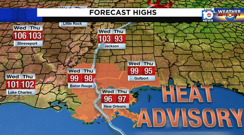
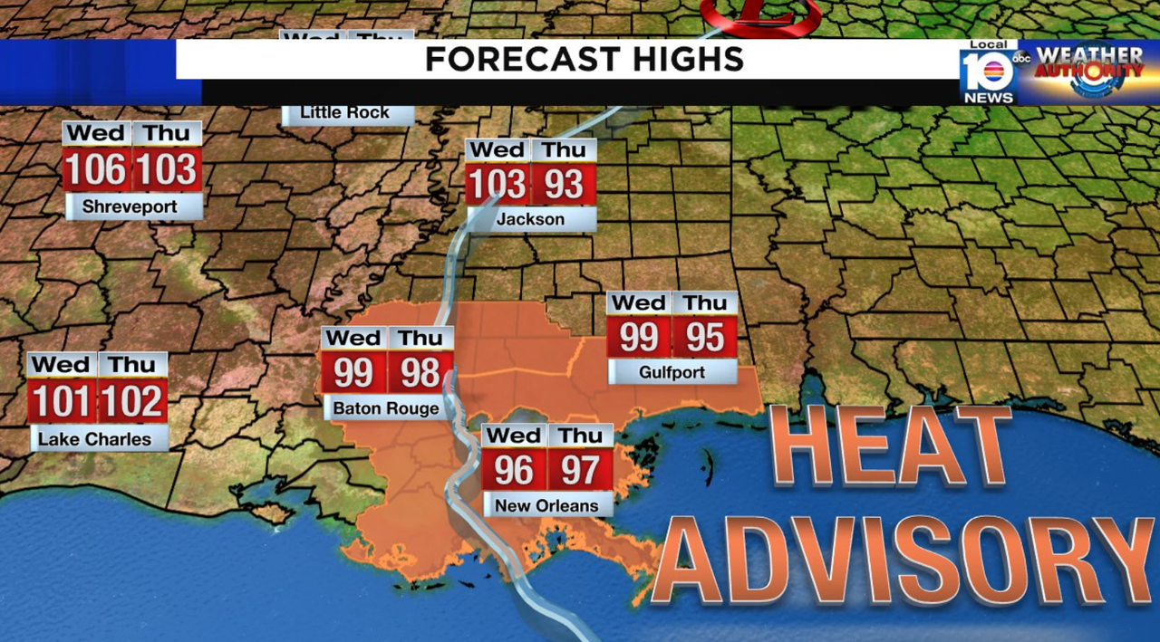
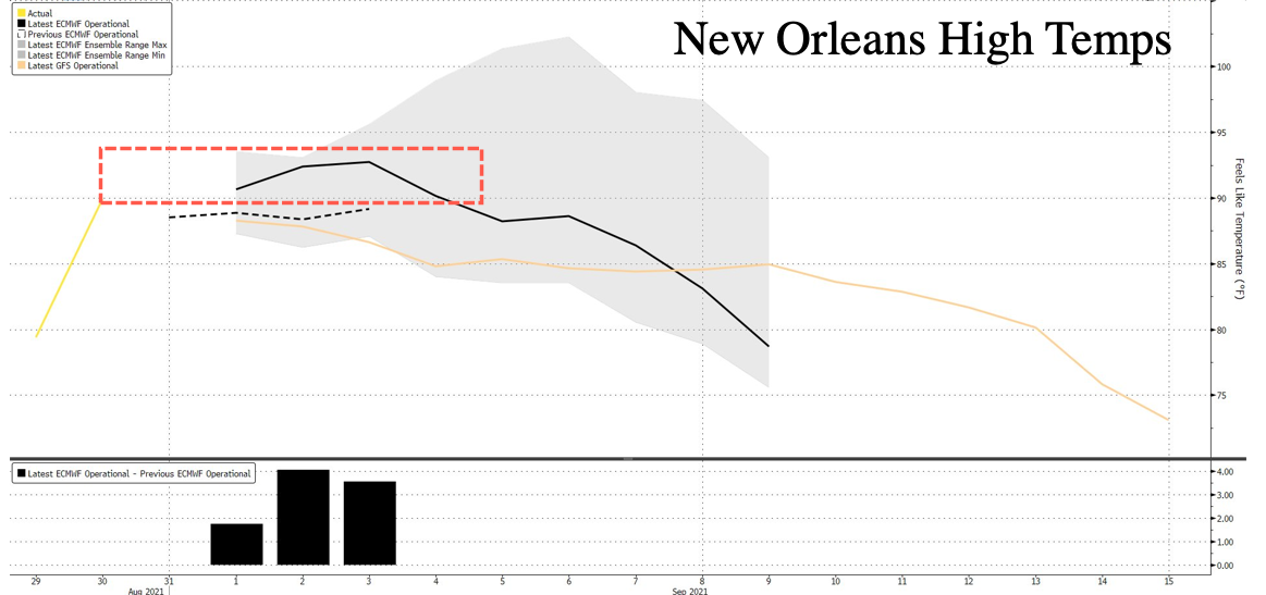
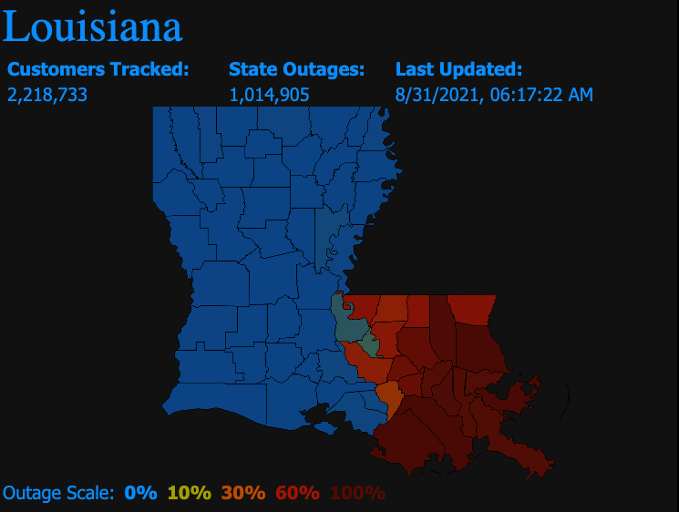
Update (1530ET): There's a lot of uncertainty when power for one million folks ravaged by Hurricane Ida in Southeast Louisiana will be restored. What's worse is that a dangerous heat wave has now pushed into the area.
Due to catastrophic damage to utility company Entergy's transmission system, a million people in Southeast, Louisiana are without power nor air condition as temperatures could push near triple-digit levels today.
Temperatures are expected the linger in the 90s through this week.

There's no telling when the power will entirely be restored, but indications so far from the governor suggest weeks. What this may imply is that a humanitarian crisis for the region is imminent.
* * *
Update (1408ET): A million people are without power after Hurricane Ida ravaged Southeast Louisiana on Sunday. The utility company Entergy experienced significant damage to its transmission system that has sent all of Orleans Parish without power.
Entergy is now reporting that it may take "several days" to figure out a timeline of the earliest date when power will be restored.
"The damage from Hurricane Ida has eliminated much of the redundancy built into the transmission system, which makes it difficult to move power around the region to customers," the company said in a statement.
There is still an emergency happening in New Orleans. https://t.co/UYN3K0H9vA— Sherrilyn Ifill (@Sifill_LDF) August 31, 2021
A grid damage assessment will give officials a better understanding of when the power will be restored in the coming days.
* * *
Update (1302ET): Moments ago, Louisiana Gov. John Bel Edwards spoke with reporters at a press conference. He said following Hurricane Ida, it may take upwards of 30 days to restore power to parts of the state. He said he wasn't "satisfied" with the timeline to restore power, adding that the situation is very dangerous, and requested that those who evacuated don't return home.

Here's part of the governor's press conference where he also went on to say that "many of the life-supporting infrastructure elements are not operating right now."
"If you have already evacuated, do not return here or elsewhere in Southeast Louisiana until the Office of Emergency Preparedness tells you it is ready to receive you," Louisiana Gov. John Bel Edwards says. "So let's get you where you can be safe and somewhat comfortable." pic.twitter.com/u095ocpLNU— MSNBC (@MSNBC) August 31, 2021
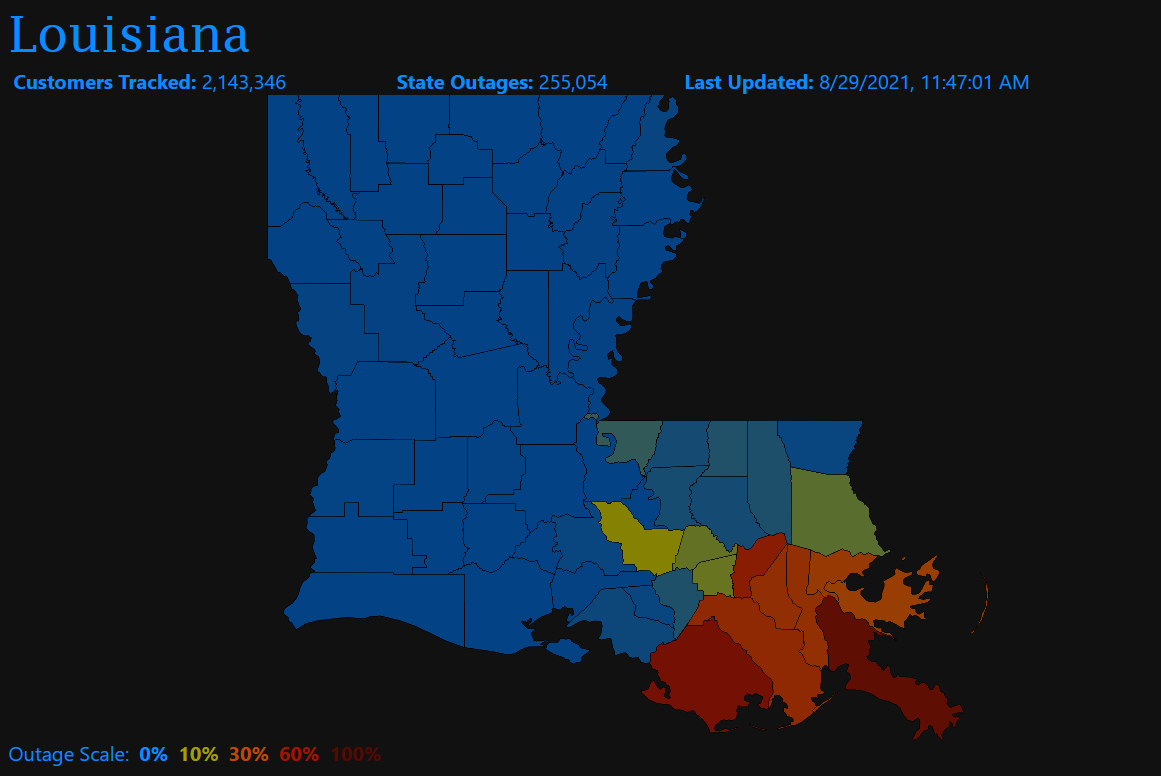
As of 1248 ET, PowerOutage.US reports a little more than one million customers are without power across the state's coastal plain.
We noted earlier that 207 transmission lines spanning more than 2,000 miles were knocked out when Ida made landfall near Port Fourchon, Louisiana, with 150 mph winds, on Sunday.
How long until looting begins?
* * *
More than a million customers across Lousiana are without power on Tuesday morning. Some reports indicate it could take weeks for the lights to come back on as thousands of miles of transmission lines were damaged after Hurricane Ida rolled through on Sunday.
The Category 4 hurricane raises fresh questions about how well New Orleans and other coastal areas across Lousiana are prepared for natural disasters. As of 0630 ET, PowerOutage.US reports a little more than one million customers are without power across the state's coastal plain.

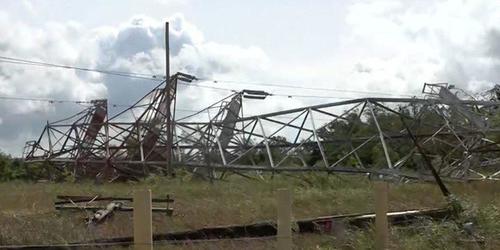
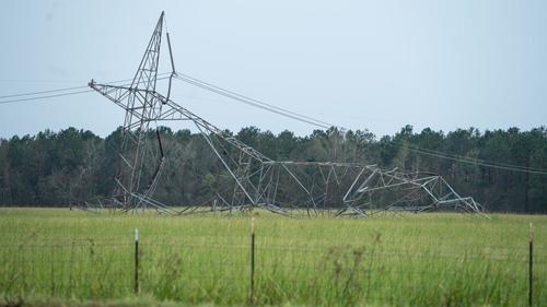
Energy provider Entergy Corp has been surveying the damage since Monday and has found 207 transmission lines spanning more than 2,000 miles have been knocked out by the storm, according to WSJ.
Rod West, Entergy's group president of utility operations, said drones, helicopters, and land-based vehicles are surveying the damage and estimate it could take at least three weeks to restore power.
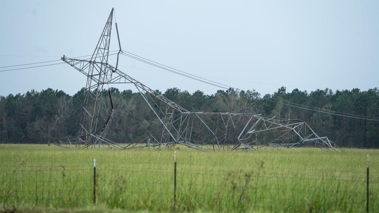
The crumpled Entergy transmission tower by River Road in Bridge City. Local volunteer firemen said it collapsed iver a two-hour period Sunday night as #HurricaneIda battered the area. /1 @NOLAnews #nola #energytwitter pic.twitter.com/IqBXVtvjuZ— Anthony McAuley (@AnthonyMcAuley2) August 30, 2021
"The hard part is that the geography is a rather wide swath," West said. "That three weeks is not going to apply to everybody the same way." He added some transmission towers need to be replaced entirely due to "significant wind" damage.
West said the damage to the transmission system is more severe than Hurricane Katrina because Ida made landfall at 150 mph.
Besides transmission lines, some of Entergy's powerplants have sustained damage. West said the damage at some plants would not hinder energy production. One of their nuclear power plants 25 miles west of New Orleans on the Mississippi River was shuttered ahead of the storm.
West said they'd rebuilt their transmission system over the years to withstand speeds of 150 miles an hour. Still, it appears some of those high-voltage cables that carry electricity from power plants to substations that connect to lower-voltage distribution lines, were no match for Ida.
It could take weeks for Entergy and other power companies to restore energy in the state.
Customers have been panic searching Generac generators and generators since the hurricane made landfall.
Searches for "generator"

Searches for "generac"

Source: ZeroHedge
All Hell is About To Break-Loose...
Update: 8/29/21 Summary:
- All of New Orleans is currently without power...
- Hurricane Ida made landfall at 12:55 p.m. near Point Fourchon, Louisiana with winds tied for the most intense hurricane on record to strike Louisiana, at 150 mph.
- As of 7pm ET, Ida was a strong Category 3 storm with maximum sustained winds up to 125 MPH.
- Max sustained winds of 150 mph, tied with two other hurricanes for record landfall.
- Over half a million residents without power
- Surge could result in 12-16 feet of inundation; so far the surge has reached at least 4 to 7 feet in southeast Louisiana and coastal Mississippi, engulfing roads, homes, businesses and marinas. New Orleans’ flood protection system, bolstered by a $14.5 billion investment post-Katrina, will be tested by Ida’s surge and torrential rain.
- The storm could unload up to two feet of rain in parts of southeast Louisiana, causing severe flash flooding.
- Downed trees and widespread power outages could last weeks
- The core of the storm’s hurricane-force winds could pass through Houma and Baton Rouge and very close to New Orleans, producing structural damage, downed trees and widespread power outages, which could last weeks.
(Update 1946ET): All of New Orleans is without power after Hurricane Ida inflicted "catastrophic transmission damage," according to Energy New Orleans.
JUST IN: Hurricane Ida has left all of New Orleans without power due to "catastrophic transmission damage," according to Entergy New Orleans.https://t.co/RdkgVmqDKW— NOLA.com (@NOLAnews) August 30, 2021
According to a c ompany spokesperson, the storm caused a "load imbalance to the company’s transmission and generation" that the company is "making every effort to identify and rectify.
(Update 1900ET): Hurricane Ida has weakened to a strong Category 3 storm with maximum sustained winds up to 125 MPH, and is currently located 30 miles SW of New Orleans, moving NW at 10 MPH.
A flash flood warning is in effect for New Orleans, with places like shell Beach has seeing over 8 feet of storm surge. Area in New Orleans such as Venetian Isles, Lake Catherine & Irish Bayou and are mandatory evacuation.
FLOODING in NOLA: Look at this in Venetian Isles in @CityOfNOLA. This is one area in New Orleans under a *mandatory* evacuation. Venetian Isles, Lake Catherine & Irish Bayou; areas outside the levee protection system. Water is almost up to the stop sign 🥺 @wdsu #HurricaneIda pic.twitter.com/RQ8uMwpWRJ— Christina Watkins (@CWatkinsWDSU) August 29, 2021
Power outages in Louisiana surge as Hurricane Ida rotates through the state, according to data from utility Entergy Corp. As of 6pm local time, some 538,173 customers were affected the utility said on its website. Outages stood at 133,722 half an hour after Ida made first landfall. Outages are currently affecting 31 of state’s 64 parishes, including those that are homes to oil refineries:
- East Baton Rouge Parish, where Exxon’s Baton Rouge refinery sits
- St. Charles Parish, home to Valero’s St. Charles and Shell’s Norco facilities
- St. Bernard Parish: PBF Chalmette and Valero’s Meraux plant
- St. John the Baptist Parish: Marathon Garyville
- Plaquemines Parish: Phillips 66’s Alliance plant
* * *
(Update 1615ET): New Orleans hit with 70mps wind gusts. With the northwestern core of Ida surging into New Orleans, winds have rapidly increased and rain is pouring down. For the next six hours or so, tropical-storm to hurricane-force winds will lash the city, causing widespread flooding, downed trees and power outages, which are already mounting. With peak wind gusts over 80 mph possible, some structural damage is also probable. New Orleans Lakefront Airport has reported a wind gust as high as 76 mph.
Social media photos and video have shown toppling trees and wires around the region and even part of a roof peeled off in the French Quarter. These dangerous conditions will probably worsen through the early evening and not abate significantly until around midnight.
1:45pm: Remarkable wind damage already taking place on Decatur Street in the French Quarter. pic.twitter.com/xs8387Ngtx— Markie Martin (@MarkieMartin) August 29, 2021
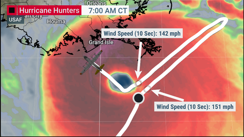
Meanwhile, to get a sense of just how powerful this storm is, hours before landfall, NOAA and Air Force Reserve Hurricane Hunter aircraft flew into Hurricane Ida, capturing the dramatic video shown above. The footage shows the clearing associated with the eye of the storm and the towering thunderstorms surrounding it. The military aircraft reported peak flight-level winds around 168 mph between 8,000 and 10,000 feet as they sampled the storm environment.
Stunning video taken from inside the eye of #Ida this morning by the NESDIS Ocean Winds Research team during a flight on the @NOAA_HurrHunter P3 aircraft @NOAASatellites pic.twitter.com/sjt970Yeiq— National Hurricane Center (@NHC_Atlantic) August 29, 2021
* * *
(Update 1515ET): Colonial Pipeline, the primary fuel artery from Houston to the South and East Coast, said it temporarily shut down its Lines 1 and 2 systems from Houston to Greensboro, North Carolina. Colonial said the rest of the network from North Carolina to New Jersey is operating normally. Colonial said the closure is precautionary and should resume full service after Ida passes and the system is evaluated.
Louisiana and other Gulf Coast utility crews also were adding extra personnel in preparation for widespread power outages across the region, and Entergy warned much of the region could lose power for close to a month.
As of about 2 pm CT, Louisiana had about 255,000 electricity customers without power, according according to poweroutage.us.

A hurricane typically causes power demand destruction, as it severs transmission and distribution lines to loads. With weaker demand, lower prices would be expected, but much of the nation's natural gas flows through Louisiana, and Ida could disrupt that infrastructure and increase pressure on gas prices.
* * *
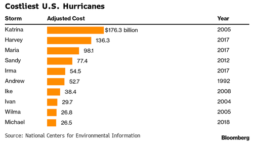
(Update 1430ET): According to Bloomberg calculations, Hurricane Ida could cause more than $40 billion in damages and losses based on its projected path according to an estimate from Chuck Watson, a disaster modeler at Enki Research. That would put it among the top 10 costliest U.S. storms, if a far cry from Katrina's $176 billion.
In addition to ripping through New Orleans, the storm is poised to batter oil refineries, chemical plants and ports. Meanwhile, according to BSEE, Gulf Operators have shut 95.7% of oil output on the hurricane. Oil explorers in the U.S. Gulf of Mexico have shut 1.74 million barrels a day of crude production and 93.8% of natural gas output as Hurricane Ida approaches, according to the Bureau of Safety and Environmental Enforcement. 288 platforms have been evacuated as of 11:30 CT Sunday.
As Platts adds, close to 4.4 million b/d of operating refinery capacity is in the path of Ida as well, primarily in Louisiana, and at least half of that at-risk capacity came offline ahead of Ida as Phillips 66, Shell, ExxonMobil, Valero and others closed refining units. Ida's wind speed will play a major role in how hard it strikes at the heart of USGC refining centers, according to S&P Global Platts Analytics. The greatest impacts are expected in the eastern Louisiana refining and petrochemical hubs from Baton Rouge to New Orleans and potentially to Mississippi.
If the hurricane comes in with 120 mph winds or stronger, it could be "a major factor" in disrupting refining and petrochemical operations, Platts Analytics said. Ida would become a Category 5 hurricane if its winds hit 157 mph.
"Hurricane Ida is expected to come ashore along the same path as other storms, which did extensive damage to USGC refining and petrochemical facilities. Many plants have been hardened against hurricanes, but disruptions in operations are still very likely due to flooding, power outages and personnel dislocations," Platts Analytics said.
Gasoline inventories in PADD III heading into the weekend were adequate at 2.5 million barrels higher relative to the five-year average, Platts Analytics said, but the storage levels could be rapidly depleted in a week to the lowest levels since February.
* * *
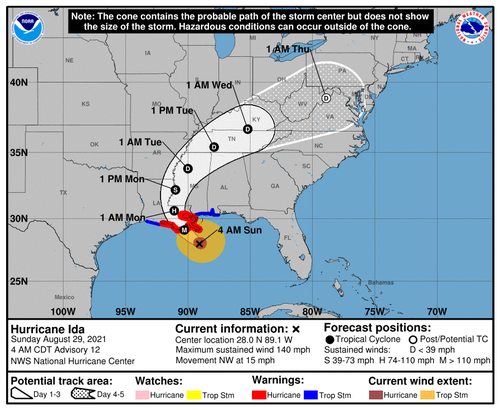
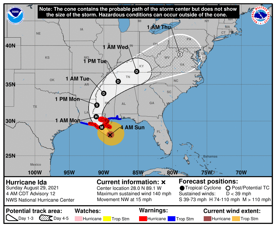
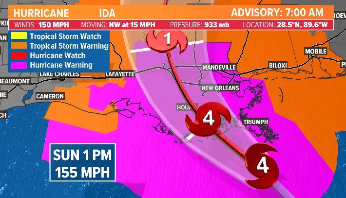
(Update: 1305ET): Hurricane Ida has made landfall in Louisiana with stronger winds than Hurricane Katrina - which hit New Orleans exactly 16 years ago today, killing over 1,800 people and leaving the area in ruins - not to mention disarmed.
🌀 @NHC_Atlantic has declared landfall of Hurricane #Ida at 1155 am CDT as a Category 4 hurricane with max sustained winds of 150 mph and a minimum central pressure of 930mb over Port Fourchon. https://t.co/7iYQ3NXNtA— NWS New Orleans (@NWSNewOrleans) August 29, 2021
Only two other storms on record have hit Louisiana with winds this powerful, Last Island Hurricane in 1856 and Hurricane Laura (2020).
"I feel sick to my stomach watching," National Hurricane Center forecaster Eric Blake tweeted on Sunday (via BBG). "This is a very sobering morning."
Near the point of Ida’s landfall late this morning at Grand Isle LA… video from Christie Angelette pic.twitter.com/QpLit2wSSR— James Spann (@spann) August 29, 2021
"This will be the most severe test of that system," said Louisiana Gov. John Bel Edwards in an appearance on CNN, adding "We believe that the integrity of that system is going to be able to withstand the storm surge."
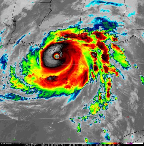
EYE OF A MONSTER: @NOAA's #GOES16🛰️gives an up-close look at the lightning swirling around the eye of #HurricaneIda, a dangerous Cat. 4 #hurricane, nearing the coast of southeastern #Louisiana. Updates: https://t.co/S9zyq5ZuZv #LAwx #MSwx #idahurricane #Ida pic.twitter.com/lhwYUy4DtN— NOAA Satellites - Public Affairs (@NOAASatellitePA) August 29, 2021
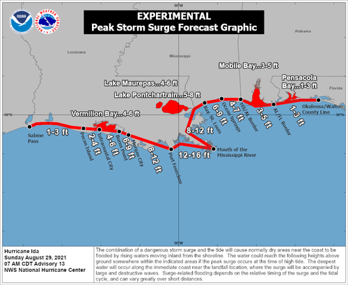
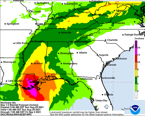
Earlier in the day, Ida was projected to drive ocean levels as high as 16 feet, with rainfall in excess of two feet.
Winds will be strong enough to rip roofs from houses, and snap trees and power poles. Blackouts could last weeks. About 33,000 homes and businesses were without power at 9:30 a.m. local time, according to Poweroutage.us, which tracks utility outages. -Bloomberg
Development of a double eyewall means that the core wind field of #Ida is broader, not a great development to see just before landfall. The storm has also begun to slow down, which was expected, but begins to reveal just how big a flooding threat Ida is. pic.twitter.com/HmluxMvr0r— Dr. Levi Cowan (@TropicalTidbits) August 29, 2021
I haven't done the calculations but I'm betting the amount of rainwater dumped on Louisiana by Hurricane Ida will exceed that of the entirety of California for the past year+
Heavy rainfall 10-20" over large area, then 3-6" all the way into New England during next several days pic.twitter.com/xzVQR3sIm6— Ryan Maue (@RyanMaue) August 29, 2021
Source: ZeroHedge
Pestilence a Deadly Disaster Disease That Affects an Entire Community… It’s interesting to me you don’t find the words plague(s) and pestilence in the New Testament under any context other than the judgment of God. (In fact, for the most part, the context of those words in the Old Testament is also within the judgment of God.)
(Update: 1305ET): Hurricane Ida has made landfall in Louisiana with stronger winds than Hurricane Katrina - which hit New Orleans exactly 16 years ago today, killing over 1,800 people and leaving the area in ruins - not to mention disarmed.
🌀 @NHC_Atlantic has declared landfall of Hurricane #Ida at 1155 am CDT as a Category 4 hurricane with max sustained winds of 150 mph and a minimum central pressure of 930mb over Port Fourchon. https://t.co/7iYQ3NXNtA— NWS New Orleans (@NWSNewOrleans) August 29, 2021
Only two other storms on record have hit Louisiana with winds this powerful.
"I feel sick to my stomach watching," National Hurricane Center forecaster Eric Blake tweeted on Sunday (via BBG). "This is a very sobering morning."
Near the point of Ida’s landfall late this morning at Grand Isle LA… video from Christie Angelette pic.twitter.com/QpLit2wSSR— James Spann (@spann) August 29, 2021
"This will be the most severe test of that system," said Louisiana Gov. John Bel Edwards in an appearance on CNN, adding "We believe that the integrity of that system is going to be able to withstand the storm surge."
EYE OF A MONSTER: @NOAA's #GOES16🛰️gives an up-close look at the lightning swirling around the eye of #HurricaneIda, a dangerous Cat. 4 #hurricane, nearing the coast of southeastern #Louisiana. Updates: https://t.co/S9zyq5ZuZv #LAwx #MSwx #idahurricane #Ida pic.twitter.com/lhwYUy4DtN— NOAA Satellites - Public Affairs (@NOAASatellitePA) August 29, 2021
Earlier in the day, Ida was projected to drive ocean levels as high as 16 feet, with rainfall in excess of two feet.
Winds will be strong enough to rip roofs from houses, and snap trees and power poles. Blackouts could last weeks. About 33,000 homes and businesses were without power at 9:30 a.m. local time, according to Poweroutage.us, which tracks utility outages. -Bloomberg
Development of a double eyewall means that the core wind field of #Ida is broader, not a great development to see just before landfall. The storm has also begun to slow down, which was expected, but begins to reveal just how big a flooding threat Ida is. pic.twitter.com/HmluxMvr0r— Dr. Levi Cowan (@TropicalTidbits) August 29, 2021
I haven't done the calculations but I'm betting the amount of rainwater dumped on Louisiana by Hurricane Ida will exceed that of the entirety of California for the past year+
Heavy rainfall 10-20" over large area, then 3-6" all the way into New England during next several days pic.twitter.com/xzVQR3sIm6— Ryan Maue (@RyanMaue) August 29, 2021
The live cams should get interesting over the next several hours:
* * *
Hurricane Ida has rapidly strengthened into a major hurricane with maximum sustained winds of 150 MPH, just seven mph shy of a Category 5. The storm is set to strike Louisiana later this afternoon/evening, and on the same day, 16 years ago, Hurricane Katrina struck the area.
As of 0600 ET, National Oceanic and Atmospheric Administration (NOAA) plane flew into the storm and found Ida is an "extremely dangerous Category 4 hurricane about to make landfall in southeastern Louisiana later today."
Reports from an NOAA Hurricane Hunter aircraft indicate that maximum sustained winds have increased to near 150 mph (240 km/h) with higher gusts. The latest minimum central pressure estimated from reconnaissance aircraft data is 935 mb (27.61 in).
An elevated NOAA C-MAN station at Pilot's Station East near Southwest Pass, Louisiana, recently reported a sustained wind of 82 mph (131 km/h) and a gust to 107 mph (172 km/h). Another NOAA elevated C-MAN station at Southwest Pass recently reported a sustained wind of 77 mph (124 km/h) and a wind gust of 93 mph (150 km/h).
Ida is currently over the Gulf of Mexico where it could strengthen even more before making landfall around 1800 ET.
A Hurricane Warning has been posted for Intracoastal City, Louisiana, to Pearl River, Mississippi.

Storm surges could be significant across Louisiana and Mississippi. For instance, a 10-foot to 15-foot storm surge is forecasted from Morgan City, Louisiana, to Ocean Springs, Mississippi. A storm surge of 5-8 feet is possible for Lake Pontchartrain.
The Weather Prediction Center warns Southeast Louisiana could expect up to 8-16 inches of rain.
Metropolitan New Orleans is expected to get swamped by the hurricane and has prompted residents to evacuate or shelter in place. Bloomberg says, "the levee gates will close in many areas, hospital wards in the region are being cleared out, oil refineries and offshore production are shutting down, and thousands of residents are fleeing for their lives."
An oil platform (KMDJ) in the path of #Ida was sending out weather information but it appears the reports stopped at 6:35AM CT. pic.twitter.com/ZTwt0v6YzW— Doc V (@MJVentrice) August 29, 2021
The menacing hurricane "could damage close to 1 million homes along the U.S. Gulf Coast" and cause upwards of "$220 billion," CoreLogic report said Saturday.
The property and data analytics firm is worried that a dangerous storm surge could hit 941,392 properties in Louisiana, Mississippi, and Alabama.
Finally, as Mike Shedlock notes, oil production is going to face serious disruptions:
- Ida's projected path has made it a threat to the vast oil refining and petrochemical complex situated along the U.S. Gulf Coast, though the storm's more easterly track Friday suggested it would miss the heart of those operations in Texas and along the Texas-Louisiana border.
- Refineries in Louisiana and Mississippi had started to reduce or halt output, which will lead to some gasoline-delivery delays.
- Projections have Ida sweeping through the bulk of U.S. offshore oil production, located south and southeast of Louisiana, said Andy Lipow, president of Houston-based consulting firm Lipow Oil Associates. He expects as much as 90% of offshore oil output to close ahead of the storm.
- "Hurricane Ida is showing up probably in the worst possible location for oil production," Mr. Lipow said.
Here's a list, courtesy of Bloomberg, of all major oil and gas production sites shuttered and their capacity in barrels per day.
- BP Plc
- Atlantis, 200,000 b/d
- Mad Dog, 100,000 b/d
- Na Kika, 130,000 b/d
- Thunder Horse, 250,000 b/d
- Royal Dutch Shell Plc
- Turritella (including Stones field) 50,000 boe/d (at peak), Stones field working to resume partial production
- Mars, 60,000 boe/d
- Olympus, 100,000 boe/d
- Appomattox, 175,000 boe/d
- Ursa, 150,000 boe/d
- Auger, 130,000 boe/d
- Enchilada/Salsa, capacity not specified
- Equinor SA
- Titan, 2,000 boe/d (producing rate in the second quarter)
- BHP Group
- Shenzi, 100,000 b/d and 50 mmcf/d gas
- Murphy Oil Corp.
- Shutting in production, up to 4,100 boe/d
- Chevron Corp.
- Shutting all oil and natural gas platforms; volume not specified
- Average net daily production in 2018 was 186,000 barrels of crude, 105 million cubic feet of natural gas and 13,000 barrels of NGLs: website
- Shutting all oil and natural gas platforms; volume not specified
- Exxon Mobil Corp. began evacuating personnel from its Hoover platform; minimal impact on production
Ports:
- Coast Guard sets condition Zulu for New Orleans
- LOOP paused deliveries until after storm
Refineries:
- Phillips 66’s 255k b/d Alliance began idling units Friday
- PBF is reducing rates at 190k b/d Chalmette
- Shell began shutting 230k b/d Norco
- Marathon is shutting production at 578k b/d Garyville
- Valero is idling production units at 125k b/d Meraux
- ExxonMobil’s 520k b/d Baton Rouge is running at ~50% capacity ahead of Ida
Expect higher gas prices and energy outages especially in the impacted regions.
Here's a live feed of the New Orleans skyline.
As the storm makes landfall this afternoon/evening, we will provide updates as needed.
"Extremely Dangerous" Hurricane Ida Almost Category 5 Strength As It Nears Louisiana
Hurricane Ida has rapidly strengthened into a major hurricane with maximum sustained winds of 150 MPH, just seven mph shy of a Category 5. The storm is set to strike Louisiana later this afternoon/evening, and on the same day, 16 years ago, Hurricane Katrina struck the area.
As of 0600 ET, National Oceanic and Atmospheric Administration (NOAA) plane flew into the storm and found Ida is an "extremely dangerous Category 4 hurricane about to make landfall in southeastern Louisiana later today."
Reports from an NOAA Hurricane Hunter aircraft indicate that maximum sustained winds have increased to near 150 mph (240 km/h) with higher gusts. The latest minimum central pressure estimated from reconnaissance aircraft data is 935 mb (27.61 in).
An elevated NOAA C-MAN station at Pilot's Station East near Southwest Pass, Louisiana, recently reported a sustained wind of 82 mph (131 km/h) and a gust to 107 mph (172 km/h). Another NOAA elevated C-MAN station at Southwest Pass recently reported a sustained wind of 77 mph (124 km/h) and a wind gust of 93 mph (150 km/h).
Ida is currently over the Gulf of Mexico where it could strengthen even more before making landfall around 1800 ET.
A Hurricane Warning has been posted for Intracoastal City, Louisiana, to Pearl River, Mississippi.
Storm surges could be significant across Louisiana and Mississippi. For instance, a 10-foot to 15-foot storm surge is forecasted from Morgan City, Louisiana, to Ocean Springs, Mississippi. A storm surge of 5-8 feet is possible for Lake Pontchartrain.
The Weather Prediction Center warns Southeast Louisiana could expect up to 8-16 inches of rain.
Metropolitan New Orleans is expected to get swamped by the hurricane and has prompted residents to evacuate or shelter in place. Bloomberg says, "the levee gates will close in many areas, hospital wards in the region are being cleared out, oil refineries and offshore production are shutting down, and thousands of residents are fleeing for their lives."
An oil platform (KMDJ) in the path of #Ida was sending out weather information but it appears the reports stopped at 6:35AM CT. pic.twitter.com/ZTwt0v6YzW— Doc V (@MJVentrice) August 29, 2021
The menacing hurricane "could damage close to 1 million homes along the U.S. Gulf Coast" and cause upwards of "$220 billion," CoreLogic report said Saturday.
The property and data analytics firm is worried that a dangerous storm surge could hit 941,392 properties in Louisiana, Mississippi, and Alabama.
Finally, as Mike Shedlock notes, oil production is going to face serious disruptions:
- Ida's projected path has made it a threat to the vast oil refining and petrochemical complex situated along the U.S. Gulf Coast, though the storm's more easterly track Friday suggested it would miss the heart of those operations in Texas and along the Texas-Louisiana border.
- Refineries in Louisiana and Mississippi had started to reduce or halt output, which will lead to some gasoline-delivery delays.
- Projections have Ida sweeping through the bulk of U.S. offshore oil production, located south and southeast of Louisiana, said Andy Lipow, president of Houston-based consulting firm Lipow Oil Associates. He expects as much as 90% of offshore oil output to close ahead of the storm.
- "Hurricane Ida is showing up probably in the worst possible location for oil production," Mr. Lipow said.
Here's a list, courtesy of Bloomberg, of all major oil and gas production sites shuttered and their capacity in barrels per day.
- BP Plc
- Atlantis, 200,000 b/d
- Mad Dog, 100,000 b/d
- Na Kika, 130,000 b/d
- Thunder Horse, 250,000 b/d
- Royal Dutch Shell Plc
- Turritella (including Stones field) 50,000 boe/d (at peak), Stones field working to resume partial production
- Mars, 60,000 boe/d
- Olympus, 100,000 boe/d
- Appomattox, 175,000 boe/d
- Ursa, 150,000 boe/d
- Auger, 130,000 boe/d
- Enchilada/Salsa, capacity not specified
- Equinor SA
- Titan, 2,000 boe/d (producing rate in the second quarter)
- BHP Group
- Shenzi, 100,000 b/d and 50 mmcf/d gas
- Murphy Oil Corp.
- Shutting in production, up to 4,100 boe/d
- Chevron Corp.
- Shutting all oil and natural gas platforms; volume not specified
- Average net daily production in 2018 was 186,000 barrels of crude, 105 million cubic feet of natural gas and 13,000 barrels of NGLs: website
- Shutting all oil and natural gas platforms; volume not specified
- Exxon Mobil Corp. began evacuating personnel from its Hoover platform; minimal impact on production
Ports:
- Coast Guard sets condition Zulu for New Orleans
- LOOP paused deliveries until after storm
Refineries:
- Phillips 66’s 255k b/d Alliance began idling units Friday
- PBF is reducing rates at 190k b/d Chalmette
- Shell began shutting 230k b/d Norco
- Marathon is shutting production at 578k b/d Garyville
- Valero is idling production units at 125k b/d Meraux
- ExxonMobil’s 520k b/d Baton Rouge is running at ~50% capacity ahead of Ida
Expect higher gas prices and energy outages especially in the impacted regions.
Here's a live feed of the New Orleans skyline.
As the storm makes landfall this afternoon/evening, we will provide updates as needed. Source: ZeroHedge
Meteorologists Warn Tropical System To Intensify Into Major Hurricane Before Gulf Coast Landfall
Update: 8/26/21 AccuWeather forecasters released a weather note Thursday about a tropical disturbance in the Caribbean Sea that has strengthened into Tropical Depression Nine and could become a major hurricane, possibly striking the US Gulf Coast Sunday/Monday.
The forecasters warned the storm could strike parts of the central Gulf Coast as a major hurricane (Category 3 or stronger) on Sunday evening or Monday.
We published a weather note on Wednesday outlining the same system to strengthen and landfall risks from Texas to Louisiana next week.
Fox 8 Meteorologist Zack Fradella told residents of South Louisiana to prepare for a major hurricane:
"We have seen this before. Expect a Cat 3 at the very least," he tweeted.
On Thursday morning, the depression was moving at 13 mph and had maximum sustained winds of 35 mph, and was approximately 115 miles south-southwest of Negril, Jamaica. The storm is expected to rapidly strengthen over the coming days when it takes a path over the central Gulf of Mexico.
"The sooner the system strengthens, the more likely it is to take a northwesterly track into the central Gulf of Mexico, rather than a westward track across Mexico's Yucatan Peninsula and into the southwestern Gulf," AccuWeather Senior Meteorologist Rob Miller explained.
AccuWeather forecasters say the cone of uncertainty points to landfall from Texas to Louisiana to Mississippi and even Alabama. Across these areas are petroleum assets on land and offshore.

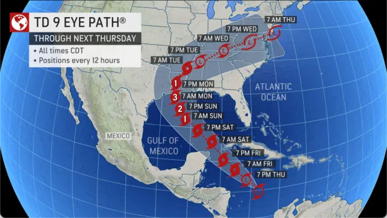
Meteorologist Phil Klotzbach from Colorado State University tweeted Tropical Depression 9 is similar to Hurricane Michael in 2018 and Hurricane Laura in 2020, both slammed US Gulf Coast states.
Tropical Depression 9 has formed in the western Caribbean. The next name on the National #Hurricane Center's list for the 2021 Atlantic season is Ida. The long-term (1991-2020) average 9th Atlantic named storm formation date is 15 September. pic.twitter.com/jm1CeA0Bhk— Philip Klotzbach (@philklotzbach) August 26, 2021
The next named storms of the 2021 Atlantic hurricane season will be Ida, Julian, and Kate. Readers should continue to monitor the storm through the weekend for updates on the landfall area.
Catastrophic Floods Decimate Two Tennessee Towns; 10 Killed, Dozens Missing
8/22/21 There is growing concern among Tennesseans after Gov. Bill Lee, a.k.a Satan Soldier quietly issued an Executive Order on Friday giving the state permission to call up the National Guard and State Guard “in connection with certain health care and emergency services operations.”
One section of Executive Order 83 would permit the construction of “temporary quarantine and isolation facilities.”
“Telephone assessments for involuntary commitment cases are permitted,” the executive order also states.
Tennessee Stands, an influential statewide conservative coalition, said they found some of the governor’s orders “exceptionally concerning.”
In Other News
With everyone fixated on the tropical system that is about to smash Long Island or southern New England, another weather event crushed two small towns in Middle Tennessee has left at least ten people dead and dozens missing, according to The Tennessean.
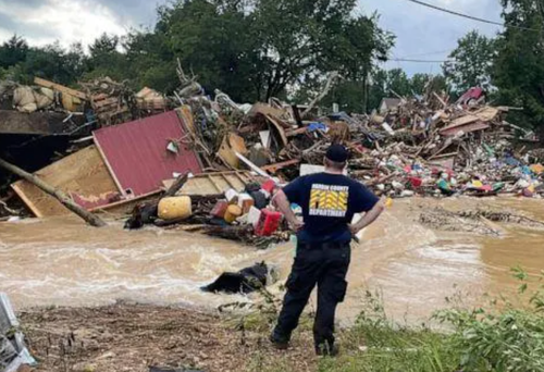
Catastrophic flooding struck the small towns of Waverly and McEwen Saturday, where as much as 17 inches of rain fell over a 24-hour period.
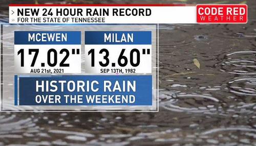
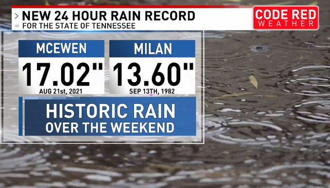
Humphreys County Sheriff Chris Davis reports ten dead and 40 missing after the flash floods. Sheriffs and other first responders are conducting door-to-door searches.
The Hardin County Fire Department, which is now supporting Humphreys County rescue operations called the destruction nothing short of "unbelievable."
Social media shows posts show destruction is everywhere. The flash flooding wiped homes and businesses off their foundations, submerged vehicles, and left millions of dollars in damage. Infrastructure was also damaged, such as roads and bridges were washed away.
The Tennessee National Guard was deployed to Humphreys County to assist residents after 15 inches of rain the area on Saturday, killing 10 people & leaving 31 missing.
Prayers for all the families here in my home State. 🙏🏼 #Tennessee #Flood #flashflood pic.twitter.com/tT20eeP89C— ∼Marietta (@ThisIsMarietta) August 22, 2021
Are you or your loved ones needing shelter after the floods in Hickman, Humphreys, and Dickson counties? See where you can receive relief items and comfort --> https://t.co/gOp2hifGdC pic.twitter.com/ADt4GxElt4— WSMV News4 Nashville (@WSMV) August 22, 2021
TUNE IN AT 8 A.M.: Catastrophic flooding in Humphreys County leaves 10 dead and 31 missing. Now, search efforts are underway, and News 4 is with a family as they look for loved ones. https://t.co/l49Mli92Fp pic.twitter.com/kUlx0GIAp5— WSMV News4 Nashville (@WSMV) August 22, 2021
According to local authorities, catastrophic flooding in middle #Tennessee left at least ten people dead and dozens missing on Saturday as record-shattering rainfall washed away homes and rural roads. pic.twitter.com/fxuswtEutt— ANews (@anews) August 22, 2021
Damage in every direction in Waverly, TN. #waverly pic.twitter.com/FWC92QEb2y— Steve Smith (@stevesmith1043) August 22, 2021
The Red Cross has arrived in the devastated county and is erecting emergency shelters on Sunday morning.
“Our volunteers and staff will begin the response of surveying the area Sunday morning and will begin to assess the needs of each community we are serving following these storms,” said Joel Sullivan, regional executive director for Red Cross of Tennessee. “We are working with our local partners and government officials to ensure that recovery services are provided to begin helping the residents get back on their feet as quickly as we can.”
Now Free Hands Cuomo Cares About His Constituents, What a Joke Satan Soldiers Can Be in Times of Crisis
Update: 8/22/21 Heavy bands of torrential rain and high winds began battering the Northeast Sunday morning, signaling the arrival of Henri by afternoon.
The National Hurricane Center (NHC) downgraded Henri from a Category 1 hurricane to a tropical storm with maximum sustained winds of 70 mph. The storm is about 50 miles southeast of Montauk Point, New York.
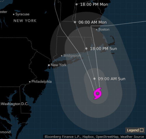
Even though the storm was downgraded by four mph from 74 to 70 overnight, damaging winds and storm surges could cause coastal and inland flooding, bring down trees and power lines.
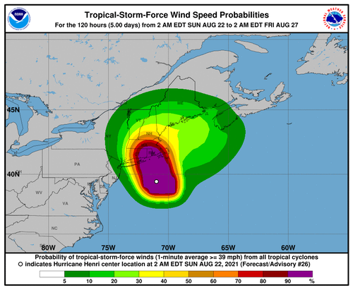
Landfall is expected late morning or early afternoon on Long Island or southern New England. The NHC said storm surge warnings and watches were in place for much of Long Island and the Massachusetts coastline. The highest surge is expected along the Long Island Sound of about 3-5 feet.
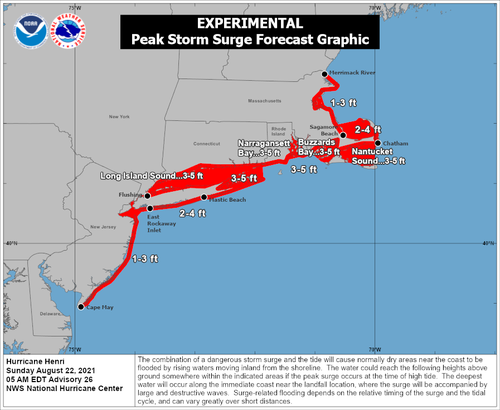
"The combination of a dangerous storm surge and the tide will cause normally dry areas near the coast to be flooded by rising waters moving inland from the shoreline," NHC warned said.
Weather models forecast Henri could dump as much as 10 inches of rain over New Jersey, New York, and western Connecticut through Monday.

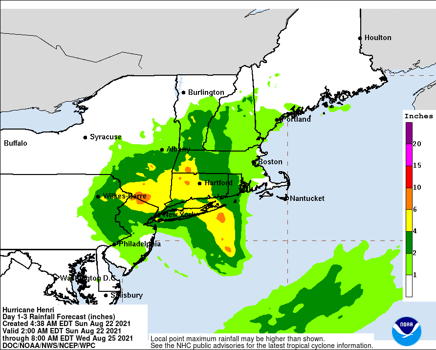
At least 50 million people in the Northeast are under tropical weather warnings or advisories. Long Island hasn't had a direct hit from a storm in three decades. It would be the first time since Hurricane Bob in 1991.
New York Gov. Andrew Cuomo warned residents of the state to get out of flood-prone areas.
"If you know you are in an area that tends to flood ... get out of that area now, please," Cuomo told reporters.
Free Hands Cuomo has declared an emergency for Long Island, New York City, Westchester, and Hudson Valley.
Dixie Fire Now Single Largest Wildfire In California History, Only 21% Contained
Update: 8/9/21 The Dixie Wildfire has scorched 489,287 acres since mid-July, making it the largest single blaze in California's history, according to USA Today.
The Golden State is under extreme drought conditions. Bone-dry vegetation fuels the fire that ravages Northern California's Butte, Plumas, Tehama, and Lassen counties. At least 400 building structures have been charred since the fire began about three weeks ago.

USA Today reports Dixie is the largest single blaze in the state's history, surpassing the August 2020 Complex fire. Last year's blaze torched more than 1 million acres and burned 900 structures, but it was a compilation of more than 30 fires ignited by lightning strikes. The current fire was sparked by a tree that fell on utility Pacific Gas & Electric's power lines.
The California Department of Forestry and Fire Protection (CAL FIRE) reports Dixie is only 21% contained Monday afternoon.

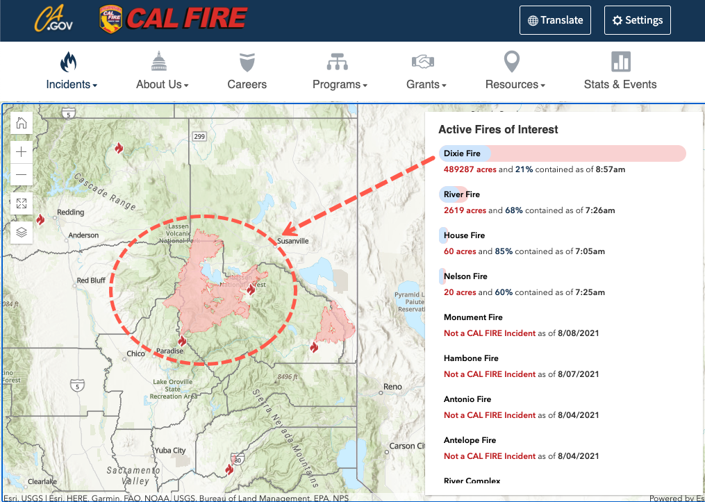
The National Interagency Fire Center (NIFC) warns, "the fire outlook continues to reflect warmer and drier conditions leading to the high potential for severe wildfire activity throughout the (West) through the rest of summer and into the fall. Widespread high temperatures ... with periods of lightning activity continue to exacerbate the wildfire situation."
Weather forecasts this week show another round of above-average temperatures is slated for the Pacific Northwest. Source: ZeroHedge
Trio Of Tropical Disturbances To Watch In Atlantic Basin
Update: 8/8/21 A trio of tropical disturbances are developing in the Atlantic basin and should be closely watched next week. Two of the disturbances have the chance of forming into tropical depressions in the next five days.
July was a quiet period after an active start (June 1) to the 2021 Atlantic hurricane season, but statistically, the busiest part of the hurricane season begins on Aug. 20. It seems a significant uptick in storms is ahead.
The first disturbance is a low-pressure system over the west-central Atlantic. The second disturbance is more east and is moving westward in the central tropical Atlantic. The third distance is near Africa.

Last week, National Oceanic and Atmospheric Administration (NOAA) upgraded the number of named storms to 21 from its prior forecast of 15 in May.
NOAA is now forecasting at least ten hurricanes and up to five major ones with winds above 100 mph.
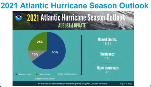
"While the tropics have been slow the past few weeks, NOAA forecasters believe a busy hurricane season lay ahead," said Matthew Rosencrans, the lead seasonal hurricane forecaster at the U.S. Climate Prediction Center.
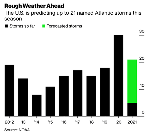
The 2020 hurricane season saw a record 30 storms, with several major ones striking Louisiana.
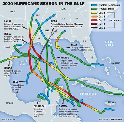
Keep an eye on tropical development in the Atlantic Basin. The next tropical storm will be named Fred. Source: ZeroHedge
California's Dixie Fire Mushrooms To State's Second-Largest Wildfire Ever
Update: 8/8/21 The Dixie Wildfire continues to ravage hundreds of thousands of acres, fueled by strong winds and bone-dry vegetation in Northern California. The wildfire has become the second-largest in California history, and the largest in the US as more than a hundred large fires burn.
PERFECT STORM: The combination of intense heat, extreme drought and powerful winds have caused the ‘Dixie fire' in northern California to become the largest of more than 100 wildfires burning in the western U.S. pic.twitter.com/24qhOmzWiB— CBS Evening News (@CBSEveningNews) August 7, 2021
Dixie incinerated more than 447,000 acres as of Saturday night, according to the California Department of Forestry and Fire Protection (CAL FIRE). The fire is only 21% contained.

The wildfire's cause is under investigation. Bloomberg said Thursday utility giant PG&E Corp.'s power lines might have played a part in sparking the fire. On Friday, a federal judge ordered PG&E to provide details about the equipment and where the fire began.
The #DixieFire is now the 2nd largest fire in California’s history. As firefighters continue their fight against 11 major wildfires/complexes across the state, please take the time to ensure you and your family are #EvacuationReady by visiting https://t.co/gIN3kS6vHF. pic.twitter.com/92PFACuLYS— CAL FIRE (@CAL_FIRE) August 8, 2021
Dozens of building structures were destroyed in the gold rush-era town of Greenville on Wednesday and Thursday.
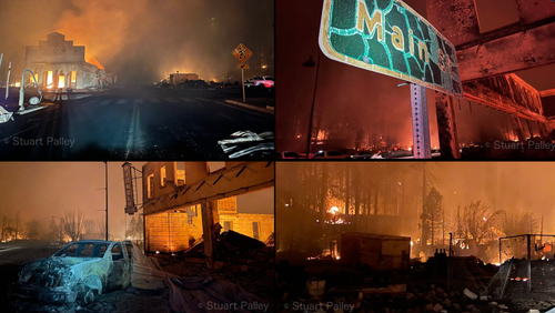
Heat waves and a historic megadrought have transformed much of the American West into a tinder box. Dixie has become the third-largest fire in recorded California history and is the largest active fire in the US.
Smoke from the wildfires is spreading across the country.
Here's a look at the smoke forecast across the country for Sunday and Monday (Aug 8-9). Wildfires continue to spread across the western US, including the #DixieFire which is now California's largest fire in recorded history. #arwx pic.twitter.com/GLIF5DALv8— NWS Little Rock (@NWSLittleRock) August 8, 2021
The National Interagency Fire Center (NIFC) reports "107 large fires have burned 2,179,454 acres" in 14 western states.
NIFC provides a grim weather forecast for the western US, stating, "the fire outlook continues to reflect warmer and drier conditions leading to the high potential for severe wildfire activity throughout the western United States through the rest of summer and into the fall."
The US Drought Monitor continues to show severe conditions across the western half of the US.
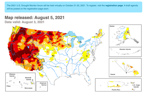
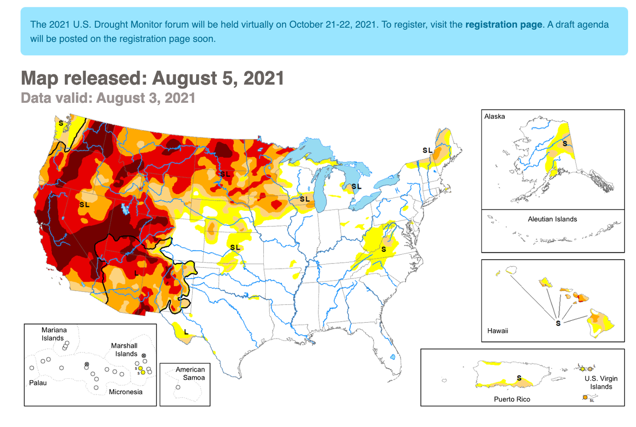
California's fire season could surpass last year's season, the worst fire season in state history.
None of this should be surprising since California's top fire officials were warning months ago that the worst wildfire season on record was quickly approaching.
Source: ZeroHedge
California Wildfires Force 16,000 Evacuations, Destroys Entire Town
Update: 8/5/21 At least 16,000 people have been evacuated as wildfires burn across Northern California.
According to Bloomberg, the Dixie Fire, which has burned more than 322,000 acres is 35% contained, may have been sparked by utility giant PG&E Corp.'s power lines.

The fire ripped through Greenville on Wednesday night, tearing through the small town about 115 miles northeast of Sacramento.
#DixieFire in Greenville, downtown is a mess, video is driving W on Main toward Hwy 89 then left or south on 89. pic.twitter.com/8S4BGwoVuQ— craig philpott (@CphilpottCraig) August 5, 2021
"We lost Greenville," U.S. Congressman Doug LaMalfa, who represents the area, said in a video statement. "We have to stop making this happen."
Another fire is brewing 60 miles south of what is left of Greenville. The blaze is called the "River Fire" and has burned more than 2,400 acres and destroyed 50 buildings.
News of PG&E's faulty equipment could be behind the Dixie Fire sent shares tumbling on Thursday, down more than 3.5%. Since Tuesday, shares are down nearly 7%.

* * *
Two massive California wildfires have triggered new mandatory evacuation orders for thousands of people and destroyed homes and businesses in the state's north overnight.

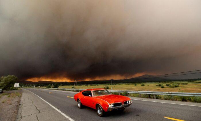
As The Epoch Times' Isabel van Brugen reports, the Dixie Fire, California's biggest blaze, which has been burning for more than three weeks, tore through a small mountain community on Wednesday evening, destroying businesses and homes as intense winds fueled the blaze.
A gas station, hotel, and bar in Greenville, Northern California, were spotted burned to the ground by a photographer on assignment for The Associated Press. According to Plumas News, the community’s library and a bank were destroyed in the blaze.
The historic town in Plumas County is home to just over 2,100 residents.
“If you are still in the Greenville area, you are in imminent danger and you MUST leave now!!” the Plumas County Sheriff’s Office said on Facebook earlier Wednesday.
“Evacuate to the south to Quincy. If you remain, emergency responders may not be able to assist you.”

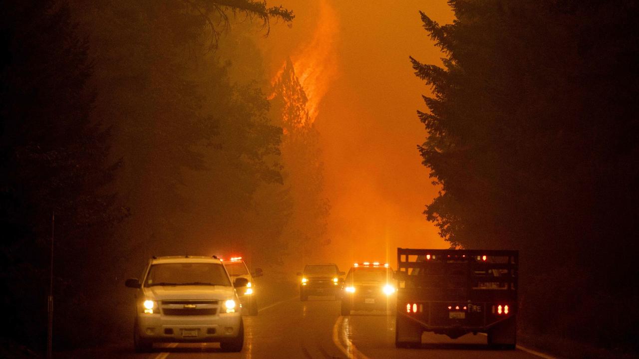
“I’ve been here since 1973 and I’ve never, ever been through anything like this,” said supervisor Kevin Goss, who represents the Greenville area and owns a business downtown, reported Plumas News.
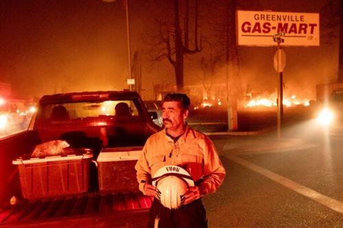
Battalion Chief Sergio Mora watches as the Dixie Fire tears through the Greenville community of Plumas County, Calif., on Aug. 4, 2021. (Noah Berger/AP Photo)
The three-week-old fire, now the 8th-largest blaze in California history, has grown to over 428 square miles (1,108 square kilometers) across Plumas and Butte counties. Firefighters had been trying to protect the town of 800 about 280 miles (450 kilometers) northeast of San Francisco by clearing debris from roads and marking hazards.
The destruction came amid a red flag warning issued by forecasters warning of hot, bone-dry conditions with winds up to 40 mph (64 kph). That could drive flames through timber, brush, and grass, especially along the northern and northeastern sides of the vast Dixie Fire.
I believe this is taken at the intersection of Mill St and Hwy 89 in #Greensville #DixieFire pic.twitter.com/gWDZmmuLP8— WXChasing (Brandon Clement) (@bclemms) August 5, 2021
Firefighters were able to save homes and hold large stretches of the blaze. But flames jumped perimeter lines in a few spots Tuesday, prompting additional evacuation orders for about 15,000 people east of Lake Almanor, fire officials said.
The heat from the flames created a pyrocumulus cloud, a massive column of smoke that rose 30,000 feet (9,100 meters) in the air, said Mike Wink, a state fire operations section chief.
The fire has threatened thousands of homes and destroyed 67 houses and other buildings since breaking out on July 14. It was 35 percent contained.
Video from #dixiefire from Greenville, Chester, Lake Almanor areas. pic.twitter.com/wilWSZcaeq— WXChasing (Brandon Clement) (@bclemms) August 5, 2021
Pandora Valle, a spokesperson with the U.S. Forest Service told the San Francisco Chronicle shortly after 8 p.m. on Wednesday that “firefighters are fighting for the town of Greenville.” She added that no further information about the extent of the fire’s damage was immediately available. Source: ZeroHedge
Southeastern Europe Devastated By Wildfires
Update: 8/4/21 A dangerous heat wave is ravaging parts of southeastern Europe resulting in wildfires across Turkey, Greece, and Italy, according to VOA News.
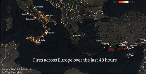
Firefighters across the European Union arrived in Turkey on Monday. The wildfires have burned for at least one week as political opposition mounts against President Recep Tayyip Erdogan for his sluggish fire response.
Turkey doesn't have firefighting planes and has had to rely on other countries, including several EU members, for aerial fire support.
Southern Europe continues to see devastating wildfires fueled by soaring temperatures. Tourists and residents in some parts are still being evacuated. The European Union said it "stands in full solidarity with Turkey", sending planes to combat roaring fires#rescEU #eusolidarity pic.twitter.com/D0byHhBOLd— IMAGO. (@imago_images) August 4, 2021
Erdogan tweeted a statement regarding the fires: "We will continue to take all necessary steps to heal our nation's wounds, compensate for its losses, and improve its opportunities even better than before."
Nex store in Greece, thousands of residents were evacuated in Athens as wildfires tore through the northern district of the metro area. Homes were burnt, and power grids were severed.
🔥🔗🇬🇷 #BREAKING 〰️〰️🎦 #ATHENS / #GRE #greecefire #Greece #wildfires #Atina #Fire #yunanistan #Catastrophe pic.twitter.com/Scj1rsKOfW— The sKy King (@sKyKingTB2) August 4, 2021
"It is a large fire and it will take a lot of work to get this under control," greater Athens regional governor George Patoulis told state-run ERT television. "The foliage is very dense in these areas and it is very dried out due to the heatwave, so the conditions are difficult."
On Tuesday, high temperatures were a blistering 115F as the country faces the worst heat wave in three decades.
"The fire is still raging, its perimeter is very wide and the heat load is very strong," a fire official said Wednesday, according to Reuters.
On Wednesday, Greek emergency services warned residents and tourists of "extreme fire danger" in Rhodes and Crete.
In Italy, firefighters used helicopters with water buckets to battle the country's wildfires along the Adriatic coast and Sicily region. Italy's National Fire Corps said air tankers from Canada supported efforts to reduce the spread of fires where at least 715 flare-ups have been observed in the past 24 hours.
🔥Wildfires are wreaking 'incalculable' environmental damage across southern Europe.
🌡️A severe heatwave left tinderbox-like conditions across Turkey, Greece, Italy and Spain.
And then the fires started…
Thread 👇https://t.co/aS4gzGo611 pic.twitter.com/PhlUf5QXdc— Telegraph World News (@TelegraphWorld) August 4, 2021
The heat wave is expected to abate in southeastern Europe after this weekend. Source: ZeroHedge
"Apocalyptic Scenes" - Wildfires Consume Turkey
Update: 7/31/21 Wildfires have been ravaging Turkey's Mediterranean coast for the past few days, killing four, burning thousands of building structures, and affecting more than a dozen provinces.
Turkish presidential spokesman Ibrahim Kalin called the wildfires a national disaster.
According to Reuters, at least 60 wildfires have broken out across the country's Mediterranean and southern Aegean region.
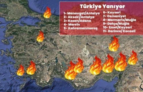
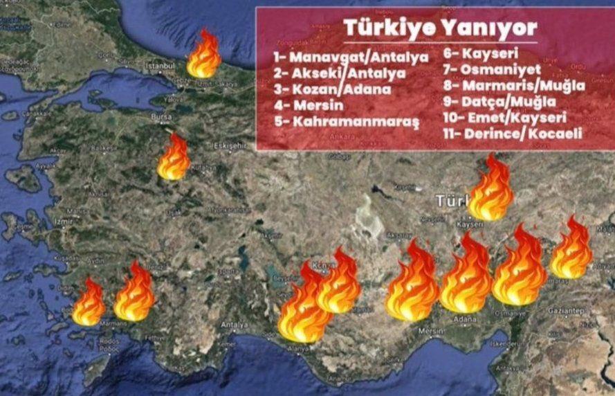
Forestry Minister Pakdemirli said 4,000 firefighters, 680 firefighting vehicles, 38 helicopters, nine drones, and three planes battle the wildfires.
"We were hoping to contain some of the fires as of this morning but while we say cautiously that they are improving, we still cannot say they are under control," Pakdemirli said.
DW correspondent Julia Hahn tweeted scenes from Manavgat in Antalya province showing "apocalyptic scenes" of one wildfire.
Apocalyptic scenes from #Manavgat in Antalya province where forest fires have killed at least three people since yesterday, and send over 50 others to the hospital. Many neighborhoods, villages evacuated.
Authorities have reported more than 40 wildfires in 13 Turkish provinces. https://t.co/ct8Xx9Hsxo— Julia Hahn (@juliahahntv) July 29, 2021
Social media is full of horrifying videos of the wildfires.
Wildfire in Turkey. The planet is on fire #Turkey #UprootTheSystem pic.twitter.com/6bXmO9bf9x— Rise up Movement (@Riseupmovt) July 30, 2021
Extreme summer wildfires are burning forests and mountains in several cities, including #Antalya and #Adana in #Turkey.🇹🇷#PrayForTurkey #Turkeyisburning pic.twitter.com/4DAwkfLt4e— khudro manush (@KhudroM) July 30, 2021
🇹🇷⚡ Wildfires in southern turkey#Turkey pic.twitter.com/91e8GqTiUe— The RAGEX (@theragex) July 29, 2021
⚠️SAD BREAKING NEWS, PLEASE SHARE AND JOIN US IN PRAYING FOR TURKEY!⚠️•Nearly 60 raging wildfires have broken out in Southern Turkey as temperatures have soared and strong winds stoked the flames the past 2 days, killing at least 4 people along with 1,000+farm animals..#Turkey pic.twitter.com/sIc5Gp4mxM— AFTAB SHAIKH (@aftabshaikh9065) July 30, 2021
Senior scientist of Copernicus Atmosphere Monitoring Service Mark Parrington used satellite data to determine the "deadly scale" of the wildfires and shows which coastal areas are most affected.
Another view of the wildfires from space.
There's still no word how the destructive fires began, but one government says "sabotage" cannot be ruled out.
Fahrettin Altun, the Turkish presidential communications director, said "comprehensive investigations" are being launched into the origins of the wildfires.
"Those responsible will have to account for the attacks against nature and forests," Altun tweeted.
Turkey has been plagued with a heat wave like much of southeast Europe.
In neighboring Greece, authorities warned the public against the heightened risk of wildfires during the latest heat wave.
"A difficult weather phenomenon is coming in the next days with extremely high temperatures and several days of heat wave," Citizens' Protection Minister Michalis Chrysochoidis said. "I call on – I urge – everyone to show the highest degree of responsibility and cooperation."
This summer has been absolute chaos across the world, heat waves in the US and Europe, cold snaps in South America, and floods in Europe and China, give climate alarmist Greta Thunberg ammunition to tweet climate disaster propaganda of how the world is ending unless governments act now. Source: ZeroHedge
Update 7/29/21 Massive 8.2 Magnitude Earthquake Rocks Alaska Peninsula
Tsunami warnings were lifted for parts of Alaska after a monster of an earthquake rocked its peninsula early Thursday.
The magnitude 8.2 quake struck off Alaska's Aleutian Islands chain, which prompted immediate tsunami warnings and evacuations in Kodiak.
According to NBC News, tsunami warnings for parts of Alaska were later lifted. A tsunami watch was also canceled for Hawaii.

The Alaska Division of Homeland Security and Emergency Management tweeted that the State Emergency Operations Center was activated.
The U.S. Geological Survey said the earthquake struck around 56 miles east southeast of Perryville, Alaska. Two quakes followed the initial one. First, 6.2 and 5.6 occurred in the same area about 30 minutes after 8.2.
There were no reports of damage or threats to Anchorage, Alaska's largest city, about 500 miles away from the quake's epicenter.
The Aleutian Islands is comprised of a dozen islands and has about 40 active and 17 inactive volcanoes. A swarm of earthquakes sometimes precedes volcanic eruptions.
In May, Alaska's Great Sitkin volcano erupted, which is part of the Andreanof Islands group in the Aleutian Islands.
Geologists are also concerned about a supervolcano lurking beneath the Aleutian Islands. There has yet to be any data if today's quakes are possibly connected with future volcanic activity. Source: ZeroHedge
Corn Belt At Risk For 'Damaging Derecho' Storms
Update 7/28/21 A derecho, otherwise known as a widespread, long-lived, straight-line wind storm, is expected to traverse parts of the Midwest Wednesday night and early Thursday, according to The Weather Channel.
Derechos can cause hurricane-force winds, tornadoes, torrential rains, and flash floods. This one could wreak havoc in the areas shaded in purple below.
What's important to note is that this derecho is sweeping across the corn belt.
A Moderate risk for severe weather remains forecast for much of the state of Wisconsin. Damaging winds (some 75+ mph) are the primary threat this afternoon and evening. Very large hail and a few tornadoes are also possible. Stay weather aware if you live within these areas. pic.twitter.com/X9uHShYykf— NWS Storm Prediction Center (@NWSSPC) July 28, 2021
Last year, a derecho rolled through Iowa and damaged about 14 million crop acres, or about 57% of the state's farms.
Across the corn belt, crops have already been damaged by sweltering heat and a persisting megadrought. This could weaken the root system and make corn more susceptible to snap under wind pressure. Source: ZeroHedge
Update 7/27/21 Crane Collapses on Milan Building Amid Hailstorm
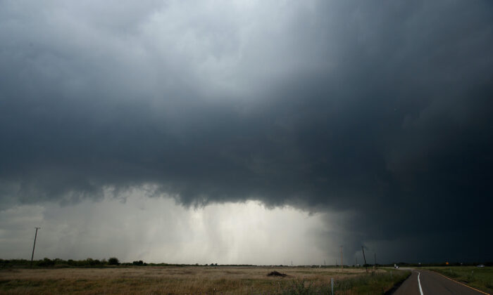
Milan—A giant crane collapsed on a six-storey building in Milan on Monday following a violent hailstorm that hit northern Italy.
The storm also caused the temporary closure of the A1 highway due to hundreds of damaged vehicles with destroyed windshields in the rescue lane.
Firefighters were at work on Tuesday to secure the area around the high building where the crane collapsed in the Rozzano area on the outskirts of Milan.
According to firefighters’ reports, nobody was injured when it collapsed and all the people in the 30 apartments in the building were immediately evacuated.
A number of people were hurt while traveling on the A1 highway, mainly by glass shards from cracked windscreens. No one is believed to have been seriously injured. Source: theepochtimes
Update 7/27/21 A freak sandstorm two hours south of Salt Lake City caused a deadly 22-vehicle pileup on Sunday, according to the Utah Department of Public Safety (DPS).
The accident occurred on Interstate 15 in Millard County on Sunday afternoon. Twenty-two vehicles were involved in the crash "after high winds caused a sand or dust storm and impaired visibility on the roadway," said DPS.
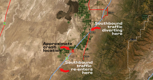
The "series of crashes" resulted in seven deaths and ten others injured, DPS said, adding that "some children" were among the deaths.

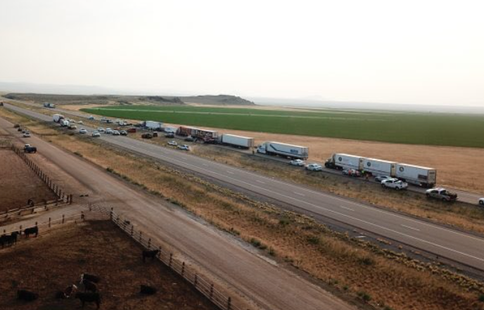
"The Utah Highway Patrol summoned troopers from Richfield and Beaver to assist," DPS said. "Multiple ground and air ambulances also responded to transport victims."
This was the chilling scene on I-15 south of Fillmore after a sandstorm caused a 20-car pileup that killed at least six people and critically injured several others. [Video: Kym Woodward] pic.twitter.com/C8goHtF4fw— KUTV2news (@KUTV2News) July 26, 2021
Sgt. Cameron Roden with the Utah Highway Patrol told local news KUTV that he "can't remember in recent memory of (a crash) being this large, with this many vehicles and this many fatalities."
"We have vehicles all over. Several vehicles tried to swerve off the roadway. We have vehicles that are flipped up on their sides," he added. "One of the vehicles that was pulling a trailer, the trailer has pretty much completely been destroyed and is on the freeway."

"We're stunned and saddened by the horrific accidents in Millard County," Utah Gov. Spencer Cox said in a statement on Twitter. "We fervently pray for the loved ones of those who perished and for those fighting for their lives."
The sandstorm comes as Utah is experiencing dangerous drought conditions and sweltering heat.
US Bird-Killing Plague Has Got A Lot Worse
Update 7/24/21
Large numbers of birds are dropping dead from a “mystery disease” throughout much of the eastern half of the country, and scientists still have absolutely no idea why this is happening. They have tested the dead birds for a whole host of known illnesses, but those tests have not revealed the cause of this plague.
We are being told that a lot of the affected birds appear to develop neurological problems, and many of them go completely blind before they finally die. The “mystery disease” has spread to more states since I first wrote about this plague, and at this point the list of affected areas includes Washington D.C., Virginia, Maryland, West Virginia, Kentucky, Delaware, New Jersey, Pennsylvania, Ohio and Indiana. If authorities are unable to find a solution, will this plague eventually spread across the entire nation?

I Don’t Know Why The Mainstream Media Is Not Giving This Story More Coverage, Because This Is Quickly Turning Into A Major Crisis.
The following comes directly from a statement that was posted late last week on the official website of the USGS…
In late May, wildlife managers in Washington D.C., Maryland, Virginia, West Virginia and Kentucky began receiving reports of sick and dying birds with eye swelling and crusty discharge, as well as neurological signs. More recently, additional reports have been received from Delaware, New Jersey, Pennsylvania, Ohio and Indiana. While the majority of affected birds are reported to be fledgling common grackles, blue jays, European starlings and American robins, other species of songbirds have been reported as well. No definitive cause(s) of illness or death have been determined at this time. No human health or domestic livestock and poultry issues have been reported.
The natural resource management agencies in the affected states and the District of Columbia, along with the National Park Service, are continuing to work with diagnostic laboratories to investigate the cause(s) of this event. Those laboratories include the USGS National Wildlife Health Center, the University of Georgia Southeastern Cooperative Wildlife Disease Study, the University of Pennsylvania Wildlife Futures Program and the Indiana Animal Disease Diagnostic Laboratory.
With Each Passing Day, More Birds Are Going Blind And More Birds Are Dying.
In Virginia, an animal control professional named Jennifer Toussaint will never forget the first time that she encountered baby blue jays that had been afflicted by this mysterious illness…
Jennifer Toussaint, chief of animal control in Arlington, Virginia, can’t forget the four baby blue jays. In late May, worried residents had delivered the fledglings to her clinic just outside of Washington, D.C., within just a few hours. Each was plump, indicating “their parents had done a great job caring for them,” Toussaint says. But the birds were lethargic, unable to keep their balance, and blinded by crusty, oozing patches that had grown over their eyes.
Toussaint and her staff soon reached a gloomy diagnosis: the jays were the latest victims of a mysterious deadly disease that had emerged in their area just a few weeks earlier and had already killed countless wild birds. There was no known treatment, so they euthanized the jays. “It was difficult to feel so helpless,” Toussaint recalls.
Experts Have Never Seen Anything Like This Before, And They Are In A Race To Try To Find Some Answers.
Whatever is causing this, it appears to be affecting a wide range of species…
Several species of birds have been affected by the mystery illness, according to the University of Pennsylvania: blue jay, European starling, common grackle, American robin, northern cardinal, house finch, house sparrow, Eastern bluebird, red-bellied woodpecker, Carolina chickadee, and Carolina wren.
And at this point, the “mystery disease” appears to have spread very widely.
For example, in the state of Virginia there have been confirmed reports “in the counties and cities of Alexandria, Arlington, Clarke, Fairfax, Falls Church, Fauquier, Frederick, Loudoun, Manassas, Prince William, Shenandoah, Warren, and Winchester.”
In Indiana, cases have now been identified in 53 different counties.
So If This Is Something That Is Spreading From Bird To Bird, It Is Spreading Very Easily And It Is Spreading Very Rapidly.
But at this point we don’t know for sure that it is some sort of a disease, because so far all of the tests that have been done haven’t come up with much of anything….
Natural resource management agencies in all of the affected states and D.C. are working with the National Park Service to investigate this event.
So far, several infectious agents have not been detected in any of the birds that have been tested, including Salmonella and Chlamydia, avian influenza, West Nile virus and other flaviviruses, Newcastle disease virus and other paramyxoviruses, herpesviruses and poxviruses, and Trichomonas parasites.
Something Other Than A Disease Could Potentially Be Causing This Plague.
We just don’t know.
At One Point It Was Being Theorized That Eating Cicadas Was Causing These Birds To Become Ill, But Scientists Appear To Have Ruled This Theory Out…
But the cicadas appear to be blameless. Birds tend to avoid eating fungus-ridden cicadas, and sick birds have been observed in areas where cicadas were rare. “It does not look like it’s a match,” says Brian Evans, a migratory bird ecologist with the Smithsonian’s National Zoo and Conservation Biology Institute.
So many strange things have been happening in 2021.
As I discussed yesterday, right now we are witnessing a horrifying plague of grasshoppers in the western half of the country, and at the same time we have a nightmarish plague of dead birds in the eastern half of the country.
On top of everything else, we are right in the midst of a “megadrought” which may end up becoming the worst in the entire history of our nation.
Many believe that it is just a “coincidence” that so many bad things are happening to us all at once, and perhaps they are correct.
But nobody can deny that our world has gotten a whole lot crazier over the last couple of years, and I expect quite a bit more craziness during the second half of 2021.
See more here: zerohedge.com
Things Are So Bad In California That Farmers Are Employing "Water Witches"
Update 7/23/21
Some refer to it as "dowsing," "doodle-bugging," or "water witching"—the practice of using a forked stick or rods to locate underground water. It sounds mysterious, but this practice has been around for hundreds, if not thousands, of years.
So why revive water witching today?
Well, vineyard and farm operators in California are experiencing some of the worst drought conditions in decades. They're getting desperate for new water sources as their wells run dry and reservoirs hit record low levels.
Rather than have faith in hydrogeologists and "science," vineyard and farm operators are putting their trust in water witches.
In Sonoma County, California, an area known for wineries, Rob Thompson, a water diviner, said the drought has increased business many folds. He said this is the "busiest I've ever been in my entire life."
Thompson's claim to fame is that he formerly owned one of Northern California's largest well-drilling companies. He's been in the business for decades and claims to have found thousands of groundwater sites across the state.
"This is the worst drought I've seen in my lifetime," Thompson said. "In California, we're going deeper and deeper," he said, adding that farmers and land managers are drilling deeper to access groundwater.
Thompson uses rods to locate groundwater in the fractures of the earth's bedrock. The method has been rejected by the United States Geological Survey (USGS) as there's no science to support it.

But that doesn't stop Johnnie White, the operations manager of Piña Vineyard Management, who runs dozens of vineyards in Napa Valley.
"I haven't ever used a geologist to find water," White said, who acknowledged water witching sounds a bit "far fetched."
Davie Piña, the owner of the vineyard management company, called the drought situation in the state a "disaster" and had a gloomy outlook for the future.
While water witching sounds a bit odd, a German study conducted in the 1990s spanned a decade that paired geologists and dowsers in Africa to drill for water and see how accurate they were. In Sri Lanka alone, drill teams drilled 691 wells under the guidance of dowsers and discovered water 96% of the time.
Now the argument that USGS makes is that "water exists under the Earth's surface almost everywhere." So it's like shooting fish in a barrel.
Nevertheless, for whatever reason, farmers and land managers across California are desperate enough to turn to water witches to save their operations from turning into dust. Source ZeroHedge
Imminent Winter Storm To Spread Across Northeast
UP-Date 2/18/21 Amid widespread power losses, at least one million Texans are without power as blackouts and grid failures continue. Old Man Winter's brutal assault across the nation this week will spread more wintery chaos to Mid-Atlantic and Northeast states on Thursday through Friday.
The National Weather Service (NWS) said more than 100 million Americans are in the path of a storm as it traversed the southern Plains earlier this week and is finally arriving on the East Coast Thursday morning.
NWS has posted Winter storm warnings and winter weather advisories from the Deep South to New York City.
Watches And Warnings

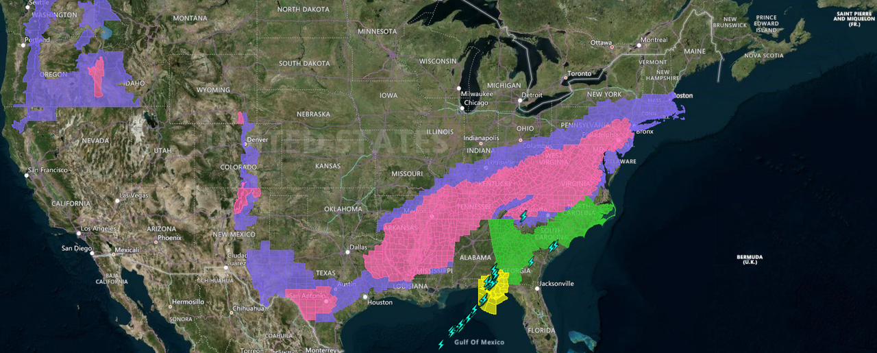
Snowfall from this storm stretches from the Northeast into the Ohio Valley and southern Great Lakes this morning. A wintery mix could be seen in West Virginia, Virginia, and parts of the Delmarva Peninsula.
Current Radar (as of 0640 ET)
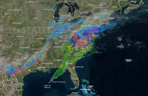
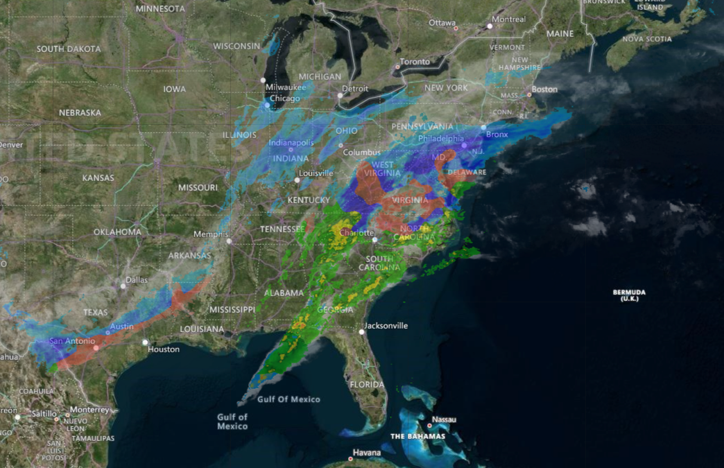
The storm will traverse the coast and spread winter precipitation across much of the Interstate 95 corridor from the Baltimore–Washington metropolitan area to Philadelphia to New York City to Boston on Thursday into Thursday night.
Forecast Timing Of Storm
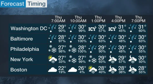
The forecast precipitation model shows the storm will be out of the Northeast by late Friday.
Forecast Precipitation Model
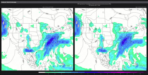
Accumulating snow is expected across the Mid-Atlantic and Northeast Interstate 95 corridor. This could make travel conditions dangerous.
Snow Total Estimates
An ice storm threat south of Washington, D.C., is expected.
Ice Threat Model

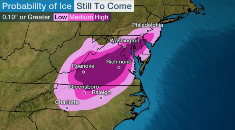
Temperatures in the Mid-Atlantic and Northeast states should stay below or around freezing for much of the winter event. By late weekend into early next week, there could be a warming trend.
Temperature Forecast
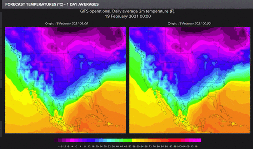
Readers may recall we outlined how another winter blast would traverse the country, strike Texas and create a second round of chaos, then eventually end up in the Northeast by late week.
Earlier in the month, in a note titled ""Overwhelming Signal" - Major Winter Storm Threats For Million Of Americans Within Next Five Days," we spoke of the storms and bitterly cold temperatures that could heavily impact the country.
... and there is some good news after the last few weeks of brutal winter weather. Heating degree days for the US-Lower 48 is set to decrease after this weekend, which means it will take less energy to heat a structure. In other words, warmer temperatures are ahead.
US-Lower 48 Heating Degree Days

Source: ZeroHedge
Is this Old Man Winter's last stand or will more winter chaos be seen later this month into March. More To Come People...
Strong Earthquake Shakes Japan's Northeastern Coast
A strong earthquake hit off the coast of northeastern Japan late Saturday, shaking Fukushima, Miyagi and other areas, but there was no threat of a tsunami, officials said.
Tokyo Electric Power Co. said there were no irregularities at the Fukushima Dai-ichi nuclear plant, which experienced meltdowns following a massive quake and tsunami 10 years ago.
There were no immediate reports of irregularities from other nuclear plants in the area, such as Onagawa or Fukushima Dai-ni, government spokesperson Katsunobu Kato told reporters.
The Japan Meteorological Agency said the quake had a magnitude of 7.3, raising it from a preliminary magnitude of 7.1.
Tokyo Electric Power Co. said that some 860,000 homes were without power as a result of the quake, but electricity was gradually being restored, according to Kato.
Kato said there was no danger of a tsunami from the quake. He said that some trains in northeastern Japan had stopped running, and that other damage was still being checked.
Video from public broadcaster NHK TV showed some pieces of a building wall had broken off and fallen to the ground, and pieces of glass were scattered at a store. Items fell off shelves because of the shaking, NHK said. NHK aerial footage showed a portion of a highway blocked by a landslide in Soma, a city in Fukushima prefecture.
The extent of damage from the landslide was not immediately clear, Kato said.
He said there were several reports of minor injuries from the quake, such as a man getting hit by a falling object.
The Japan Meteorological Agency said the quake was centered about 55 kilometers (34 miles) beneath the ocean, changing it from the earlier estimate for 60 kilometers (37 miles).
Prime Minister Yoshihide Suga headed into his office immediately after reports of the quake, and a crisis center was set up there. He said there were no reports of major injuries.
“We will continue to respond, putting human lives first,” Suga told reporters early Sunday.

The shaking was felt in Tokyo, to the southwest.
The same northeastern area was slammed by a quake, tsunami and nuclear disaster in March 2011. Experts warned of aftershocks over the next several days, including possibly larger quakes.
Some people were taking shelter at evacuation centers, and were being warned to practice social distancing because of the coronavirus pandemic.
Source: NewsBreak
Polar vortex brings most extreme winter weather in years

From wind chills near 60 below zero in the Upper Midwest to an ice storm all the way to the Gulf Coast, it is rare that winter weather gets this extreme. The culprit is a polar vortex teaming up a very active jet stream.
That means cold, snow and ice for hundreds of millions of Americans.
On Saturday, more than two-thirds of the nation was under some kind of winter weather alert running the gamut from wind chill warnings in the northern Plains to winter storm warnings for the Pacific Northwest. There were also winter weather advisories in South Texas and ice storm warnings in the Mid-Atlantic.
A few weeks ago, the polar vortex, which is typically located near the North Pole, broke into pieces — a natural occurrence that happens every couple of winters. Smaller daughter vortices scattered around the Northern Hemisphere, bringing pockets of Arctic air to Siberia, Europe and North America.
For the past week, one of the daughter vortices has set up shop, spinning near the U.S.-Canada border. As a result, temperatures have been frigid, at times dropping below -40 degrees Fahrenheit, but the coldest of air has been confined to the far northern U.S. That's about to change as lobes of the vortex rearrange its orientation, sending cold air south.
Over the coming days the vortex will act as a catapult, slingshotting systems around it's circulation, day after day, from coast to coast. As storms wind up, it will progressively draw the cold air further south.
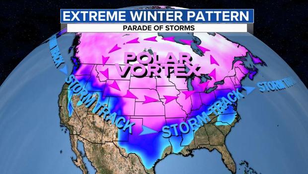
By Sunday and Monday the bitter cold air currently over the Northern Plains will plunge to the heart of Texas, bringing with it wind chills below zero. The image below traces the origin of the cold air from the Arctic Ocean, down through Canada and southward through the U.S. Plains.https://platform.twitter.com/embed/Tweet.html?creatorScreenName=https%3A%2F%2Ftwitter.com%2Fweatherprof&dnt=true&embedId=twitter-widget-1&frame=false&hideCard=false&hideThread=false&id=1360280136894005248&lang=en&origin=https%3A%2F%2Fwww.cbsnews.com%2Fnews%2Fpolar-vortex-most-extreme-winter-weather-in-years%2F&siteScreenName=CBSNews&theme=light&widgetsVersion=889aa01%3A1612811843556&width=550px
Temperatures will be dangerous. On Sunday morning in North Dakota, Minnesota and Wisconsin wind chills will bottom out in the -40 to -60 degree Fahrenheit range.
Trending News
- Pharmacies offering COVID-19 vaccines: What you need to know
- Polar vortex brings most extreme winter weather in years
- "The other woman" in the Jennifer Dulos case to detectives: "I didn't do it"
- "Jeopardy!" champion Brayden Smith has died at 24
Lows will drop below zero from Saturday to Tuesday morning in Kansas City, possibly dropping as low as -15 on Monday or Tuesday morning. With the wind factored in, wind chills Sunday, Monday and Tuesday mornings will range from 20 to 30 below.
Even Dallas Texas will experience feels temperatures well below zero on Monday and Tuesday morning. Actual temperatures will be 50 degrees below normal by Monday morning in much of Texas and Oklahoma.
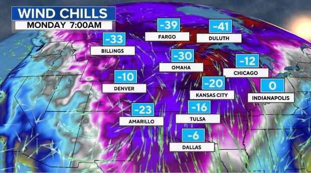
Normal high temperatures this time of year range from 55 in Oklahoma City to 60 in Dallas. Instead, on Monday, temperatures will struggle to rise above the single digits, an astonishing 50 degrees below normal.
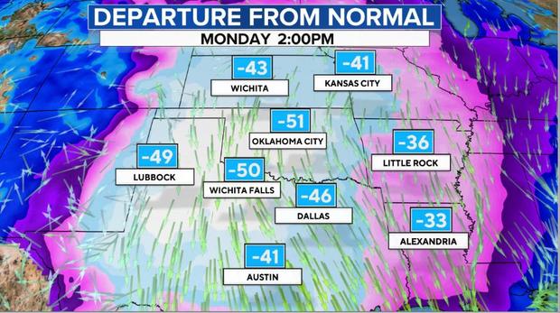
Despite being extreme, it's not nearly as extreme as it could be. Over the past few decades, due to human-caused climate change, the coldest extremes are getting less extreme. As one example, in Minneapolis the coldest day each year is now 12 degrees warmer than it used to be.
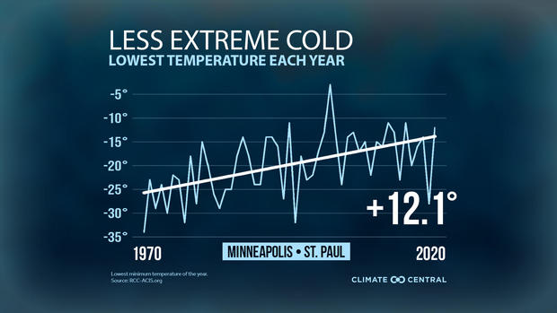
Bitter cold air is only half of the concern. A parade of storms is moving across the nation this weekend. Snow and ice accumulations will cover more than half the nation and stretch from coast to coast.
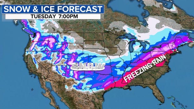
In Seattle and Portland, several inches of snow is piling up with a season's worth of snow in 24 hours expected in Seattle. It could be one of the snowiest storms since 1985.
That same storm will dip south across the Rockies producing powder for skiers on Saturday night. On Sunday, places that rarely get significant snow like Oklahoma and Texas will get dumped on. A general 5 to 10 inches are possible from Oklahoma City to Dallas, with snow falling further south into Austin.
As the cold air meets up with moist Gulf of Mexico air an ice storm will break out down to the beaches on the Gulf Coast from Corpus Christi and Houston to Lake Charles, Louisiana. This ice storm will translate northeast across Jackson, Mississippi, and into Tennessee on Monday, with a sheet of ice an inch thick making for dangerous travel and widespread power outages.
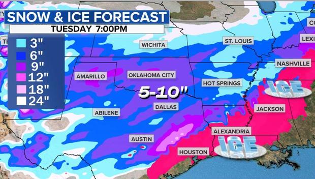
That storm will enter the Ohio Valley, Mid-Atlantic and Northeast Monday night and Tuesday. Here precipitation will run the gamut from rain and ice near the coast in places like New York City and Boston, the heavy snow in Ohio, western Pennsylvania, Upstate New York and New England.
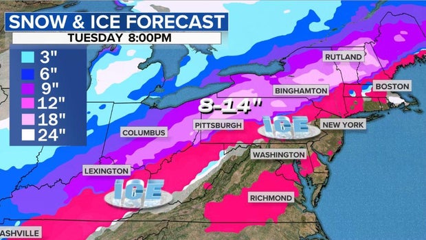
Later in the week the pattern will begin to gradually moderate as the polar vortex loses its grip. CBSNews
"Energy Emergency" - Texas Power Provider Warns Of Rotating Outages As Cold Weather Tests Limits Of Grid
Wholesale power for delivery Sunday was trading at anywhere from $3,000 to $7,000 a megawatt-hour in some places, triple the records set in some places Saturday and a staggering 2,672% increase from Friday at Texas’s West hub. Average spot power prices were just shy of $1,000 per megawatt hour during peak hours Sunday morning, according to data compiled by Bloomberg.
As one Houston energy trader so eloquently explained, Texas electricity customers are about to get "lubelessly pounded" as prices explode:
Scary as shit surge...
Sunday day ahead cleared 4765 for the peak and 2297 for the offpeak. HANDS DOWN BY FAR HIGHEST CLEAR ON RECORD.
And yep, all those folks on griddy were paying 9$ per KWh earlier today and continue to get lubelessly pounded
“Spot prices are expected to hit $9,000 on both Monday and Tuesday,” said Brian Lavertu, a trader for Active Power Investments.
“Power is going to be wild through Tuesday.”
“It is a pretty brutal air mass,” said Bob Oravec, senior branch forecaster at the U.S. Weather Prediction Center.
“The cold air is entrenched across the middle part of the country. High temperatures are amazingly cold, some 50 degrees below average.”
And, the situation in Texas doing from bad to worse: Weather forecast models suggest the polar vortex will continue pouring Arctic air into much of the central US through Feb. 20.
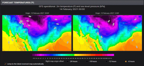
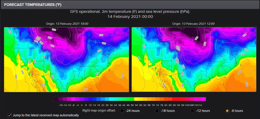
As a result of this, Texas power grid operator ERCOT, has issued a statement warning of an "energy emergency" and threatening "rotating outages" just when residents need the power to heat their homes the most:
The Electric Reliability Council of Texas (ERCOT) is asking consumers and businesses to reduce their electricity use as much as possible Sunday, Feb. 14 through Tuesday, Feb. 16.
"We are experiencing record-breaking electric demand due to the extreme cold temperatures that have gripped Texas," said ERCOT President and CEO Bill Magness.
"At the same time, we are dealing with higher-than-normal generation outages due to frozen wind turbines and limited natural gas supplies available to generating units. We are asking Texans to take some simple, safe steps to lower their energy use during this time."
Here are some tips to reduce electricity use:
- Turn down thermostats to 68-degrees.
- Close shades and blinds to reduce the amount of heat lost through windows.
- Turn off and unplug non-essential lights and appliances.
- Avoid using large appliances (i.e., ovens, washing machines, etc.).
- Businesses should minimize the use of electric lighting and electricity-consuming equipment as much as possible.
- Large consumers of electricity should consider shutting down or reducing non-essential production processes.
- Given the prolonged, below-freezing temperatures, conservation measures should be implemented safely and within reason.
ERCOT has the tools and procedures in place to maintain a reliable electric system during tight grid conditions. If power reserves drop too low, ERCOT may need to declare an Energy Emergency Alert, or EEA. Declaring an EEA allows the grid operator to take advantage of additional resources that are only available during scarcity conditions.
There are three levels of EEA, and rotating outages are only implemented as a last resort to maintain reliability of the electric system.
Other markets moving on the cold:
- Gas in Chicago hit $220 per mmBtu, traders said.
- Physical gas was going for as much as $300 per mmBtu at a Texas hub.
- Oklahoma gas prices have swung anywhere between $50 to the high of $600.
- Spot gas prices across the eastern U.S. remained subdued amid milder temperatures, assessed at anywhere from $4 per to $12 per mmBtu on Friday, pricing data compiled by Bloomberg show.
This decision from ERCOT comes after we first warned of an imminent crisis on Thursday, when we reported that nat gas prices across the plains states had soared to never before seen levels as a result of a brutal polar vortex blast...
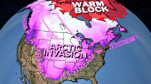
... which literally cut off nattie supply amid wellhead freeze-offs, cutting production receipts just when they're most needed by customers' demand for heating, we said that since the winter blast is expected to last for the duration of the week, it is likely that nattie prices across the plains states could hit GME batshit levels.https://platform.twitter.com/embed/Tweet.html?dnt=false&embedId=twitter-widget-0&frame=false&hideCard=false&hideThread=false&id=1360060979334291456&lang=en&origin=https%3A%2F%2Fwww.zerohedge.com%2Fenergy%2Fenergy-emergency-texas-power-provider-warns-rotating-outages-cold-weather-tests-limits-grid&siteScreenName=zerohedge&theme=light&widgetsVersion=889aa01%3A1612811843556&width=550px
One day later that's exactly what happened because as frigid temperatures caused equipment failures, temporarily shutdowns and flaring in at least four nat gas processing plants ...
- Targa Resources’ Benedum Gas Plant in Upton County affected for 7 hours overnight, co. said in a filing
- Occidental Petroleum’s Bennett Ranch Unit RCF Facility in Yoakum County, which is used for EOR, was affected for 9 hours Thursday: filing
- DCP Midstream’s Goldsmith Gas Plant in Ector County affected for 1 hour Thursday: filing
- Occidental’s nearby gas plant, another EOR facility, was affected by DCP Midstream incident: filing
... we hit the proverbial offerless market where any natgas that was available would be purchased at virtually any price, which is why midcontinent prices such as the Oneok OGT nat gas spot exploded from $3.46 one week ago, to $9 on Wednesday, $60.28 on Thursday and an insane $377.13 on Friday, up 32,000% in a few days. This is one of those places where having a limit up circuit breaker could actually be useful, even though there simply is nowhere near enough product to satisfy demand at any price hence the explosive move.

Hubs across the Midcontinent led the surge in prices again Feb. 12 as weather forecasts predicted the coldest temperatures in more than a decade would hit the region over the upcoming holiday weekend. Platts reported that at locations across Kansas, Oklahoma and Eastern Arkansas, hub prices were trading at single-day record highs around $200 to $300/MMBtu. Regional hubs, which typically service only limited local demand, saw fierce competition among shippers, utilities and end-users looking to meet weekend requirements.
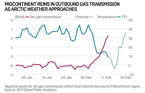
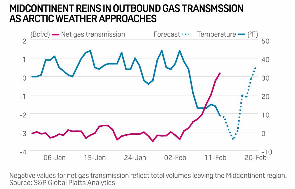
At one Enable Gas Transmission location, the cash market traded as high as $500 with weighted-average prices holding steady by mid-session around $359/MMBtu. At other nearby hubs, cash markets moved to dizzying, record highs with One Oak Oklahoma at $374 (chart above), Southern Star at $275, Panhandle at $225 and ANR Oklahoma at $205. At the region's benchmark location, NGPL Midcontinent, the market was holding around $205/MMBtu, data from the Intercontinental Exchange showed.
And as end-users across the Midcontinent compete for available gas, shippers moved quickly to cut transmissions to neighboring markets. On Feb. 12 net, inbound shipments of gas climbed to 180 MMcf/d – their highest on record dating back to 2005. In January, the Midcontinent region – which typically delivers gas to neighboring markets – saw net outbound transmissions average nearly 3.1 Bcf/d.
Of course, as natgas went offerless it was just a matter of hours before the immediate downstream commodity, electricity, would follow suit and that's precisely what happened overnight as wholesale electricity prices across all US markets on Friday.
Echoing what we said on Friday, Platts wrote that "as arctic air mass continues to blanket much of the central US, the US National Weather Service has issued multiple severe weather notices. Widespread wind chills warnings and advisories are extended through Feb. 14 and likely into the next week for much of the Upper Midwest and Midcontinent, as well as some areas in the Northwest and northern Texas. Daily temperatures across some of the locations will range between 30 to 40 degrees below average, according to the NWS. Eastern PJM, Northwest and much of Texas are also under winter storm warnings and winter weather advisories."
This is catastrophic news not only for the continued freeze in nat gas distribution, but for the explosion in electricity prices which could see many customers see a February electricity bill in the thousands, if not tens of thousands. This is what a power trader at a Houston energy company advised us on Friday:
Prices in response to the persistent cold have pushed load expectations to all time winter highs, and on par with the hottest summer days the ISO has experienced. Actual shortages could persist if units aren't weatherized and fail at any point. Monday peak is currently bid 4000, and balweek inclusive of Tuesday through Friday is 1000@2000. Off peak (nights) have traded insane levels as well, with the balance of the month trading 650$. For reference, summer of 2018 never came close to touching these levels. The highest trade on a balday was around 2000$, if i'm not mistaken.
The PUC is meeting today to discuss coordination and potential conservation efforts, but this event will likely crush several firms who are not collateralized enough to weather (no pun intended) the storm IMO. And all those folks on griddy could literally be looking at paying 4$+ per KWh across the state (as opposed to 12 cents or whatever rate you got at your house), pushing power bills to the moon.
One day later, and the peak price in Ercot west real-time hit an absolute all time high of $5,500, up from $302 the day before. If anyone has a little extra nat gas in storage, this is the time to sell it and buy a private island.

What follows is a breakdown of how the nat gas supply collapse is impacting soaring electricity prices across the US, courtesy of Platts:
Texas
ERCOT next-day prices reached record highs on the Intercontinental Exchange as temperatures throughout Texas were forecast to tumble double digits on Feb. 15. Dallas temperatures were forecast to drop to 8 degrees Fahrenheit, and Houston was forecast down to 34 F, according to CustomWeather.
The brutally cold temperatures also affected wind supply in ERCOT, generation for Feb. 15 was forecast to tumble down 52.5% to 27.8 GWh of generation as cold temperatures impacted wind turbines. DeAnn Walker, chairman of the Public Utility Commission of Texas, said at a meeting on Feb. 11 that there were some "issues with some gas generation plants being curtailed" and that "wind turbines are all frozen," further placing upward pressure on already sky-high prices.
ERCOT North Hub real-time next-day Feb. 15 on-peak power prices skyrocketed to trade above $3000, up from its previous settlement of $325/MWh. Next-day prices broke high records, and they had not seen similar four-digit prices since Aug. 15 2019, when prices settled around $1848/MWh.

ERCOT North Hub real-time balance-of-the-week for Feb. 16 through Feb. 19 surged to top $1500/MWh, and the balance-of-the-month off-peak package for Feb. 16 through Feb. 28 climbed about $499.75 to trade at $650/MWh.
In response to the unprecedented scramble, the Texas oil/gas regulator, the RRC, approved emergency provisions, and warning that the deep freeze may have a "severe impact" on energy supplies, said that power plants may struggle to acquire gas for generators.
Bloomberg's Javier Blas said, "Texas utilities are asking citizens to conserve electricity if possible as ERCOT prices surge across the board above $5,000 Per MWh (!!!) and hit the $9,000 cap in many nodes. Texas electricity grid is facing massive demand as cold weather hits southern and central U.S. states."

Bloomberg's Rachel Adams-Heard shared a tweet from a Texas power trader... https://platform.twitter.com/embed/Tweet.html?dnt=false&embedId=twitter-widget-1&frame=false&hideCard=false&hideThread=false&id=1360630907657461765&lang=en&origin=https%3A%2F%2Fwww.zerohedge.com%2Fenergy%2Fenergy-emergency-texas-power-provider-warns-rotating-outages-cold-weather-tests-limits-grid&siteScreenName=zerohedge&theme=light&widgetsVersion=889aa01%3A1612811843556&width=550px
Central
In the Midcontinent ISO, Indiana Hub on-peak jumped to its highest price since January 2019 to trade above $100/MWh. Bal-of the-week also rallied to price on par with the next-day flow package. As polar vortex continues to impact the region, the February-to-date average day-ahead price jumped almost 70% month on month and nearly doubled year on year. MISO demand forecast for Feb. 15 is the strongest since August 2020 at 98.63 GW.
As of Feb. 12, MISO is declaring conservative operations due to extremely cold temperatures and generator fuel supply risks through Feb. 16. All transmission and generation maintenance will be suspended in the affected areas, and all outages plans should be reviewed, according to the most recent grid operator's notice.
In PJM, AD Hub on-peak traded in the upper $70/MWh, rising double digits day on day. PJM West Hub also rose to trade in the mid-$60s/MWh. Power demand was forecast to begin retreating slightly in the upcoming days, however, it was still expected to remain relatively strong.
West
West power prices surged to the triple digits, the highest prices of the year so far, as a Pacific storm system was forecast to hit the Pacific Northwest to generate heavy snow and ice accumulations from Portland to Seattle. Mid-Columbia on-peak for Feb. 15 and Feb. 16 delivery boosted about $116.25 to trade at $155/MWh, and the off-peak package hiked about $113.50 to trade around $146.75/MWh.
California packages for Feb. 15 and Feb. 16 rose, with SP15 on-peak up about $117/MWh to trade around $193/MWh, and NP15 on-peak climbing $32.75 to trade around $106.75/MWh. California Independent System Operator peakload demand supported the rally in prices, with forecast demand for Feb. 15 up 1.9% to 26.7 GW.
Southwest packages saw price increments in the $200s/MWh across the board also as the weather service forecast wind chills between -10 and -25 degrees common across eastern New Mexico. Palo Verde on-peak priced around $270.25/MWh, and Four Corners on-peak traded at $314/MWh.
Northeast
Power packages in the ISO New England and NYISO were more mixed in Feb. 12 trading. Mass Hub on-peak tumbled from its recent highs to trade in the mid-$70s/MWh. Bal-of-the-week, in contrast, rose $3 to price at $87.50/MWh.
The locational marginal prices in the New York Independent System Operator were also rangebound, with Zone G adding about $2.50 to trade around $91.25/MWh and Zone J NYC falling about $7 to $94.50/MWh. The corresponding off-peak packages each rose about $5.50 to trade in the mid-$70s/MWh. Despite some of the declines, regional power prices in both ISOs remained elevated.
Unlike the rest of the country, the US Northeast is set to experience more settled weather, with high temperatures in Boston and New York City forecast to slightly increase to the low 30s on Feb. 15 with moderate chances of snow and rain, according to the weather service. ZeroHedge
You MUST Know The Truth, Chaos Is Coming: The US To Start Testing People With Flu Symptoms, Plagues Of ‘Biblical Proportions...
Brace for chaos: in a few weeks, the next person to sneeze may be arrested quietly pulled aside by the authorities and tested for coronavirus.
People in the US experiencing flu-like symptoms will be screened for the latest coronavirus that originated from China, officials with the Centers for Disease Control and Prevention announced during a briefing on Friday, adding that it will roll out 5 labs, in Chicago, Los Angeles, New York, San Francisco, and Seattle, to screen patients through the ominously sounding "national flu surveillance program"; if that wasn't bad enough, they also said the program is likely to expand as more confirmed cases are expected in the coming days and weeks.
Justifying the move, CDC officials said that there could be undetected cases of the mysterious illness in communities across the US, as the country experiences a dramatic spike in flu as the season approaches its halfway point.
The agency plans to expand to more cities until it has achieved "national surveillance".

"They are currently testing for influenza. The idea is they will test the influenza negative specimens," said Nancy Messonnier, director of the CDC's National Center for Immunization and Respiratory Diseases. There are now 15 confirmed cases of Covid-19 in the US and more than 600 people remain in quarantine.
Which, of course, is a prudent move, if only it wasn't for the fact that tens of millions of Americans are about to get sick as we enter the peak of flu season, and every sneeze or cough will lead to panicked phone calls to the local ER (or police), and potentially in self-imposed quarantine as more and more Americans await an "all clear" signal before life returns back to normal. Alas, with the coronavirus pandemic running rampant in China, this may not happen for many months.
Global cases of the virus have topped 64,000, including hundreds of health workers in China as it battles to contain the virus following its outbreak in Wuhan. In the US, there have been 15th confirmed coronavirus infections while more than 1,300 people have died in China (it would have been even more had China not somehow "double-counted" the dead).
The latest case in the US involves a patient who was among a group of people under a federal quarantine order in Texas following a US government-chartered flight that evacuated US citizens from China earlier this month.
Meanwhile, health officials report 26 million flu infections in the US so far this season, including 14,000 deaths.
Doctors working on the front lines of the novel coronavirus (COVID-19) outbreak have told the Taiwan Times that it's possible to become reinfected by the virus, leading to death from sudden heart failure in some cases.

"It’s highly possible to get infected a second time. A few people recovered from the first time by their own immune system, but the meds they use are damaging their heart tissue, and when they get it the second time, the antibody doesn’t help but makes it worse, and they die a sudden death from heart failure," reads a message forwarded to Taiwan News from a relative of one of the doctors living in the United Kingdom.
The source also said the virus has “outsmarted all of us,” as it can hide symptoms for up to 24 days. This assertion has been made independently elsewhere, with Chinese pulmonologist Zhong Nanshan (鍾南山) saying the average incubation period is three days, but it can take as little as one day and up to 24 days to develop symptoms.
Also, the source said that false negative tests for the virus are fairly common. “It can fool the test kit – there were cases that they found, the CT scan shows both lungs are fully infected but the test came back negative four times. The fifth test came back positive.” -Taiwan Times
Notably, one of the ways coronaviruses cripple the immune system is via an HIV-like attachment to white blood cells, which triggers a 'cytokine storm' - a term popularized during the avian H5N1 influenza outbreak - in which an uncontrolled release of inflammatory 'cytokines' target various organs, often leading to failure and in many cases death.
The cytokine storm is best exemplified by severe lung infections, in which local inflammation spills over into the systemic circulation, producing systemic sepsis, as defined by persistent hypotension, hyper- or hypothermia, leukocytosis or leukopenia, and often thrombocytopenia.
...
In addition to lung infections, the cytokine storm is a consequence of severe infections in the gastrointestinal tract, urinary tract, central nervous system, skin, joint spaces, and other sites. (Tisoncik, et. al, Into the Eye of the Cytokine Storm)(2012)
According to the 2012 study, "Cytokine storms are associated with a wide variety of infectious and noninfectious diseases and have even been the unfortunate consequence of attempts at therapeutic intervention."
How do coronaviruses enter the body?
With SARS (sudden acute respiratory syndrome), another coronavirus, researchers discovered that one of the ways the disease attaches itself is through an enzyme known as ACE2, a 'functional receptor' produced in several organs (oral and nasal mucosa, nasopharynx, lung, stomach, small intestine, colon, skin, lymph nodes, thymus, bone marrow, spleen, liver, kidney, and brain).
ACE2 is also "abundantly present in humans in the epithelia of the lung and small intestine, which might provide possible routes of entry for the SARS-CoV," while it was also observed "in arterial and venous endothelial cells and arterial smooth muscle cells" - which would include the heart.
This has led some to speculate that Asians, who have higher concentrations of ACE2 (per the 1000 genome project) may be affected to a greater degree than those of European ancestry, who produce the least of it - and have largely been the asymptomatic 'super spreaders' such as Diamond Princess coronavirus victim Rebecca Frasure.
And so while more research on COVID-19 is urgently needed - we know that coronavirus can target ACE2 receptors, which are found in the cardiovascuar system. And we have seen evidence of both sudden collapses and neurological damage from footage pouring out of Wuhan, China.
If the virus can reinfect patients and cause cytokine storms and sudden death - possibly exacerbated by therapeutic intervention - treating the coronavirus which CDC director Dr. Robert Redfield says will become widespread throughout the United States 'this year or next,' it is vitally important to understand exactly how COVID-19 works, and how to treat it. That would require cooperation from China and a CDC team on the ground in the epicenter. For some unknown reason, however, China still refuses to grant US scientists access to ground zero. Don't forget, Per Mr.Trump once warn weather get here all will be GREAT...
The Ugly
This ‘Ugly’ scenario would see the virus continue to rage in China, spread to ASEAN, Australia and New Zealand, and the cluster of cases in the US and Europe snowball at an exponential growth rate from their current low base. In other words, developed economies would also be hit.
If the virus spreads in the West public panic would naturally be the immediate response. Just as seen in China today, people would stop going out and shopping to stay safe at home, or make panic purchases on fears of supply shortages and then stay at home. In short, the economy would largely grind to a halt.
Naturally, the services sector on which the West relies far more than China would be smashed: restaurants; pubs; bars; cinemas; concerts; conferences would all grind to a halt. International travel bans would be put in place. Supply chains would be broken. International trade would collapse along with domestic demand.
The government would immediately start to institute similar quarantine steps as seen in China. Regardless of the differences in political systems, quarantine is quarantine (and the word originates from Venice, after all). Presuming this was ineffective due to earlier symptom-free transmission then the quarantine would have to be expanded. We could expect a mirror of the Chinese villages building barriers around themselves to keep strangers out.
In this kind of scenario, it is impossible to estimate the precise impact on the global economy – because there would be little *global* economy to speak of. Suffice to say, it would be a true depression: a sharp downturn like in 2008-09 that grinds on - and a recovery based on medical breakthroughs rather than monetary-policy ones.
The Unthinkable
This scenario is very short. The flu like virus spreads globally and also mutates, with its transmissibility increasing and its lethality increasing too. The numbers infected would skyrocket, as would casualties. We could be looking at a global plandemic, and at scenarios more akin to dystopian Hollywood films than the realms of economic analysis. Let’s all pray it does not come to pass and just remains a very fat tail risk.
However, one can see that in each of these four scenarios things are ugly, even in the first two ones. As such, the relative financial market optimism still seems to be based on the belief that central-bank liquidity supersedes virus transmissibility. That’s still quite optimistic given the uprise in uncertainty about the coronavirus.
Why Is The Government Turning 11 Military Bases Inside The United States Into Quarantine Camps?
If this coronavirus outbreak is not a serious threat, then why is the U.S. government preparing to quarantine victims all over America? As you will see below, 11 U.S. military bases located close to major airports are being converted into “quarantine centers” for potential patients. When I first learned about this, I was greatly alarmed, because we have all seen what is going on in China right now. People are literally being physically dragged out of their homes and are being forcibly relocated to “mass quarantine camps” with hordes of other very sick people. Sadly, many of them will never come out of those camps alive. If this flu like virus starts spreading like wildfire here in the United States, is it possible that something similar could start happening here?
The vast majority of the confirmed cases are still in China, but over the last couple of weeks, the number of cases in the rest of the world has escalated dramatically.
Back on January 20th, there were only 4 confirmed cases outside of China and now there are 464. At this point, there are victims in at least 28 different countries, and that number is almost certain to keep growing.
The reason why the virus has already spread to so many nations is that it is highly contagious. Scientists have discovered that it can be transmitted from person to person very easily, it has an incubation period of up to 24 days, and it can survive on smooth surfaces for up to 9 days.
If this coronavirus starts spreading very rapidly in the western world it is going to create a tremendous amount of panic. Many are still trying to compare this virus to the common flu, but that is a huge mistake. China would never lock down major cities for weeks on end for the flu.
Obviously something really big is happening, and the U.S. government is preparing for a worst-case scenario. According to the Miami Herald, 11 military bases inside the United States are currently in the process of being transformed into “quarantine centers”…
Eleven military bases near major airports in the United States are setting up quarantine centers for possible coronavirus patients, the Department of Defense said.
The Department of Health and Human Services asked the Pentagon for quarantine space in case beds fill up at other coronavirus centers around the country, according to a DOD statement.
Is this an indication that the threat that this virus poses to our country is far greater than we are being told?
The Department of Defense has released a statement about this new program, and in that statement, the 11 military bases were specifically identified…
- JB Pearl Harbor-Hickam, HI (HNL)
- Great Lakes Training Center Navy Base, IL (ORD)
- Naval Air Station Joint Reserve Base, TX (DFW)
- March ARB, CA (LAX)
- Travis AFB, CA (SFO)
- Dobbins ARB, GA (ATL)
- Fort Hamilton, NY (JFK)
- Naval Base Kitsap, WA (SEA)
- Joint Base Anacostia, DC (IAD)
- Joint Base McGuire-Dix-Lakehurst, NJ (EWR)
- Fort Custer Training Center (DTW)
Hopefully, not all of those facilities will be needed, but things are certainly looking grimmer with each passing day.
For example, the number of confirmed cases on a cruise ship anchored off the coast of Japan nearly doubled on Monday. Of the total number of people that have been infected, at least 24 of them are Americans…
There are at least 24 Americans among the 135 people infected with the Wuhan coronavirus aboard the Diamond Princess cruise ship, according to information from Princess Cruises and a CNN tally.
Japanese authorities are still testing hundreds of passengers on board the ship, which has been stuck at a harbor south of Japanese capital Tokyo for almost a week now.
Once the quarantine of that cruise ship is over, those Americans will certainly want to return home.
Will they be allowed to do so, or will they be required to go to one of these quarantine centers first?
Elsewhere in the country, people are being put in “self-quarantine” until officials believe that it is safe for them to resume their normal lives. According to local officials, this is being done to “an unspecified number of people in Bexar County” right now…
A number of Texans have been put in ‘self quarantine’ in their homes in case they have the coronavirus after recently returning from China.
Officials in the city of San Antonio confirmed that an unspecified number of people in Bexar County were being confined to their homes for 14 days.
Their quarantine period began at 10am Sunday, News 4 San Antonio reported.
Hopefully, they know what they are doing because if this virus gets out of control it could potentially sweep across America like wildfire.
We have already seen what has happened in China, and we definitely do not want that to happen here.
The Chinese have implemented extreme measures in a desperate attempt to slow the spread of the virus, but so far the most effective thing that they have done to reduce the numbers is to literally change the definition of a “confirmed case”. The following comes from Zero Hedge…
As reported by local media this morning, the Chinese National Health Commission quietly changed its definition of Coronavirus “confirmed case” in the latest guideline dated 7/2. As a result, going forward patients who tested positive for the virus but have no symptoms will no longer be regarded as confirmed. As Alex Lam observes, “this inevitably will lower the numbers.”
Of course there has been a tremendous amount of skepticism about the numbers that China has been giving us from the very beginning, and so this latest move isn’t that surprising.
But no matter how much China tries to spin things, there is no hiding the fact that this is a very serious outbreak, and it will almost certainly continue to intensify in the weeks ahead.
At this point, even the director-general of the World Health Organization is admitting that “we may only be seeing the tip of the iceberg”…
Tedros Adhanom Ghebreyesus, director-general of the World Health Organization, warned that the numbers may not tell the entire story.
“There’ve been some concerning instances of … spread from people with no travel history to China,” Tedros said. “The detection of a small number of cases may indicate more widespread transmission in other countries. In short, we may only be seeing the tip of the iceberg.”
As I discussed yesterday, humanity is now facing a “perfect storm”, and what we have witnessed so far is just the beginning.
Personally, I am still hoping that this outbreak will fade. I don’t know if this is the sort of extremely deadly global pandemic that so many experts have been warning could happen one day, but without a doubt, it is definitely clear that a lot of people are dying over in China.
Will the final death toll from this outbreak eventually number in the thousands or the millions?
I don’t know, but all of us should definitely continue to monitor the latest developments on a daily basis.

In another recent discovery, doctors and scientists are sounding the alarm that flesh-eating bacteria is spreading, which is a sign of how the earth and its waters are changing pointing to that foretold in the prophecies.
Chinese authorities announced Tuesday that two people have been diagnosed with the pneumonic plague at a hospital in Beijing — yes, as in the ‘Black Death’ which wiped out some 50 million of the world’s population during the Middle Ages.
Alarmingly, it’s the second instance of the plague hitting the region in a matter of months, after last May a Mongolian couple died from bubonic plague after consuming the raw kidney of a marmot, based on a local folk practice.
Officials say the two in this latest case also came from a remote area of Inner Mongolia in Northern China. To mitigate panic, the Chinese Center for Disease Control and Prevention has reportedly issued a public advisory to Beijing residents telling them the potential for contracting the disease is “extremely low,” according to The New York Times. Though considering this is literally the plague we doubt anyone will feel reassured by such official advisories.
The patients were quickly isolated by health officials after initial confusion over what they might be dealing with, and are reportedly being given treatment. Left untreated it will cause certain death, but some strains of the plague can be cured through careful administration of antibiotics, unavailable when it struck on a mass scale in medieval times.
What we are witnessing in East Africa and across much of the Middle East right now is hard to believe. 360 billion locusts are eating everything in sight, and UN officials are warning that this plague of “Biblical proportions” could get many times worse over the next several months. Desert locusts can travel up to 93 miles a day, and each adult can consume the equivalent of its own weight in food every 24 hours. These voracious little creatures are traveling in absolutely colossal swarms that are up to 40 miles wide, and they continue to push into new areas. If urgent action is not taken on a massive scale, millions upon millions of people could soon have next to nothing to eat.
Where Are the WatchMan_ the WatchMan That Would Boldly Confront the Ruling Class with Harsh Truths...
I have previously written about the horrors that this plague is causing in east Africa, but many people don’t realize that this plague is devastating crops throughout the Middle East as well.
In fact, the government of Pakistan just declared a national emergency because of these locusts…
A locust plague is wreaking havoc in Pakistan as ‘unprecedented and alarming’ swarms ravage crops as shocking video shows millions of the insects sweeping through Saudi Arabia.
Pakistan’s government declared a national emergency at the weekend after an infestation of desert locusts arrived in eastern Pakistan.
In Saudi Arabia, the swarms have been so thick at times that they have completely blocked out the sun, and video footage coming out of that country is getting attention all over the world…
Meanwhile swarms of locusts have been milling the skies in Saudi Arabia, with one video circulating online showing the sky saturated with the insects.
Another shows a tree in Saudi Arabia crawling with desert locusts, which consume their own bodyweight in food each day.
But of course, east Africa remains the hardest-hit region, and UN officials are warning that a horrible famine could rapidly develop as a result of this plague. The following comes from Scientific American…
Locust swarms of biblical proportions are threatening crops across a wide swath of Africa and southwest Asia—spurring alarm among top international officials.
A major concern is famine. The United Nations is warning that mass swarms of desert locusts are endangering food supplies in eastern Africa. In response, officials in Rome mobilized an emergency briefing yesterday in a bid to raise money—noting the situation has a high potential to devolve into a full-blown crisis.
"Huge" infestation is threatening to destroy communities and economies in east Africa that is entirely reliant on local food supply. One media source likened it to a Biblical Locust Plague With Swarms the Size of Cities.
The invading locusts are "deadly" in the sense that these 'mega-swarms' devour crops at an incredibly rapid pace — at a faster rate of destruction than other natural disasters.
A motorist in Kenya filmed one of the latest apocalyptic swarms in east Africa.
The clip was taken from an unknown location in Kenya, shows the moment when a motorist drove into a swarm of millions of locusts.
Out in the distance, a black blob can be seen, looks almost like a cloud, but when the vehicle drives closer, it turns out to be locusts.
If locust swarms are coupled with a COVid-19 breakout, parts of Africa could be in great danger. Week 7 into the new decade, and it seems the world is on fire.
It would be incredibly difficult for me to overstate the scale of this crisis.
According to the Daily Mail, the number of locusts has now reached 360 billion…
A locust plague decimating crops and livestock pastureland in east Africa, including swarms 40 miles wide, threatens to trigger a humanitarian crisis, the UN has warned.
The horde of 360 billion insects has laid waste to farmland across Ethiopia, Kenya and Somalia, caused damage in Dijibouti and Eritrea, posing an unprecedented threat to food security.
There are less than 8 billion people living on the entire planet.
So this swarm of locusts outnumbers us by a margin of more than 45 to 1.
And what these locusts want more than anything else is food. If you doubt the destructive power of these swarms, please consider what the FAO’s senior agriculture officer recently had to say…
“It’s certainly the most dangerous migratory pest in the world, desert locust,” said Keith Cressman, FAO’s senior agriculture officer. “A swarm the size of Rome can eat enough food in one day as everybody in Kenya.”
And some of these swarms are actually bigger than the city of Rome.
I know that may be difficult to believe, but it is true.
In Somalia, officials are calling this crisis “a national emergency” as the locusts consume “huge amounts of crops”…
Somalia’s agriculture ministry on Sunday called the outbreak a national emergency and major threat to the country’s fragile food security, saying the “uncommonly large” locust swarms are consuming huge amounts of crops.
Over in Kenya, things are even worse. At this point, the only viable way to combat these swarms is to spray them, and the UN is desperately asking for financial help to aid in that effort…
Just five planes are currently spraying as Kenyan and other authorities try to stop the locusts from spreading to neighboring Uganda and South Sudan. The United Nations has said $76 million is needed immediately to widen such efforts across East Africa.
A fast response is crucial. Experts warn that if left unchecked, the number of locusts could grow by 500 times by June, when drier weather will help bring the outbreak under control.
UN officials keep claiming that the number of locusts could get 500 times larger over the next few months, but I am having a really hard time believing that this plague could possibly get much worse than it is now.
Unfortunately, conditions are very favorable for breeding, and these locusts are constantly searching for new sources of food. They will continue to migrate in new directions, and they will eat crops everywhere they go.
According to Scientific American, the breeding cycles over the next couple of months could push the locust swarms as far as India…
Cyclones that struck the driest parts of the Arabian Peninsula last year triggered the current crisis, creating ideal conditions for the desert locust species to multiply. Left to breed in isolated corners of Saudi Arabia and Yemen, the locust swarms crossed to the Horn of Africa where they were given further support by another cyclone.
More breeding cycles are expected. The swarms increase in size twentyfold with each successive generation and could reach India by June.
When I first told my wife about this locust plague she was absolutely horrified.
She wondered what all those people would eat if all their crops were gone. Of course, the truth is that they aren’t going to have much of anything to eat.
These locusts are going to create a famine, and the more they eat the worse the famine will become.
We have never seen anything like this before, and this is yet another “unprecedented crisis” that we can add to all the others that we are currently facing.
Our planet is changing, global weather patterns are going absolutely nuts, and worldwide events are really starting to spiral out of control.
And at this point, we are just a little over one month into 2020. If you think that things are bad so far, just wait until you see what is coming over the course of the rest of the year.
The outbreak of this mysterious new coronavirus is getting more frightening with each passing day. As you will see below, even the mainstream media is admitting that the number of cases shows “no signs of slowing” even though the Chinese government has implemented draconian measures in a desperate attempt to contain the virus. Many in the western world continue to insist that this disease is not any more dangerous than the common flu, but the Chinese never locked down entire cities for the flu before. In recent days, the images that have been coming out of China have been absolutely horrifying. If these images are accurate, people are literally dropping dead in restaurants, in shopping malls, and in public transportation hubs. At the epicenter of this outbreak, crematoriums in Wuhan are burning bodies 24 hours a day as they try to keep up with the flood of dead bodies coming in, and the workers at those facilities are completely and totally overwhelmed.
The B.e.a.s.t Is Built, It Appears Pres. Trump Will Be a Big Part of the Coming Tribulation
Trump Administration Considering Social Credit Score System to Determine Who Can Buy a Gun, the Anti-Christ System Is in Place and ready to be Implemented
THE MARK OF THE BEAST WILL BE AN END-TIMES IDENTIFICATION REQUIRED BY THE ANTICHRIST IN ORDER TO BUY OR SELL.

The Trump administration is considering launching a social credit score-style system in coordination with Big Tech that would use spy data collected from Amazon, Google and Apple devices to determine whether or not an individual can own a gun.
“The proposal is part of an initiative to create a Health Advanced Research Projects Agency (HARPA), which would be located inside the Health and Human Services Department,” reports the Daily Caller. “The new agency would have a separate budget and the president would be responsible for appointing its director.”
In other words, data collected from devices that spy on private conversations and closely monitor user behavior would be used to strip Americans of their fundamental rights.
“Though the proposal is starting as a voluntary data collection scheme allegedly aimed at finding warning signs of mental illness, we all know so-called “voluntary” government programs often become mandatory at the drop of a hat,” comments Chris Menahan.
According to the Washington Post, Trump has reacted “very positively” to the idea.
MSM, High-Tech & Reddit Engaged in Heavy Censorship of Truthful News Sources
Source: HNewsWire CensoredNews ZeroHedge Themostimportantnews
StevieRay Hansen
Editor, HNewsWire.com
Google, No More Electronic Prison: You will see many changes on HNewsWire, one of those changes will be to eliminate Google Ads, the other difference, HNewsWire will NOT post videos on YouTube, it is no longer a question about overreach by the un-godly big tech tyrants. There is no question Big Tech can and will persecute any opposing opinion, they will demoralize, sideline truth seekers and those that speak the truth. The People's Blood is on big tech and mainstream media's hands. Censorship has NOT worked for thousands of years, their evil tactics will not work now, history proves me right, so we watch the drama play out between good (GOD) and evil ( Big Tech MSM ), God has never failed his people, and God will not fail this time…
StevieRay Hansen
The Un-Godly — Those That Suppress the Truth, the social media giants built multi-billion dollar empires by giving everyone a voice, but now that they have such a dominant position on the Internet they have decided that many prominent conservative voices should be completely silenced.
In order for sin to work, there has to be a “suppression of the truth.”
The World leaders Are Having Trouble With The Truth, and The World Has been "Quarantined" Tribulation Is Here…
Question — Why Are These High-Tech Conglomerates Afraid of the Truth? The answer, Because They Know the American People Have Become Lazy, Like Sheep They Need a Leader and They Chose High-Tech, It Will Be the Downfall of This Country Unless the People Change Course or the Mindset of These High-Tech Elitists stop suppressing the truth. If the people don't wake-up, they will begin to live in the worst nightmare of their lives, "Lost Social Media Reality"…
Demon Virus
Asked about the virus while traveling abroad last week, Trump said: "We have it totally under control". In a separate Twitter posting, he offered reassurance but scant detail for his confidence. By Associated Press Updated On: 05:53 PST, Jan 31, 2020
Yes, are we seeing a slowdown in new virus cases reported this morning. We now have 31,481, which does show a day-to-day decline away from an exponential rate of growth if accurate. Yet for those market participants merrily saying this is “just the flu” (there are some) we also have 4,824, 15% of the total, in critical condition and 638 deaths. Further, one arguably cannot measure the death-rate of any virus against the number of currently sick people: you surely measure it against those who eventually recover vs. those who don’t. Given we have 1,563 who have recovered vs. 638 dead (and 4,824 critical) that is a worrying ratio of 29% dead as an end-outcome, which is right up there with the MERS virus from a few years ago – although, yes, there is real reason for us all to hope that number will decline sharply as milder cases will be fully curable. But the simple flu this is not.
WASHINGTON: Wuhan coronavirus: Donald Trump says deadly outbreak 'very well under control' as WHO declares a global emergency. President Donald Trump regaled a friendly New Jersey campaign crowd with his thoughts about impeachment, the economy, the border wall, local politics and much more.
But he was conspicuously quiet on January 28 about one big issue keeping much of the globe on pins and needles: the spread of a deadly new type of coronavirus. It has killed more than 170 people in China, sickened thousands more there and led to a handful of confirmed cases in the US, including the first US case of person-to-person transmission reported on by health officials. The State Department on January 30 advised all US citizens against traveling to China.
Trump, a self-described germaphobe, generally has discussed the virus in broad terms, but he offered some of his most extensive comments on the issue to date during an appearance on January 30 at a Michigan manufacturing plant. "Hopefully, it won't be as bad as some people think it could be, but we're working very closely with them (Chinese) and with a lot of other people and a lot of other countries, he said. “We think we have it very well under control."
The Birth Pains Are Growing Stronger….
One of the signs of ruling class collapse is when they can no longer enforce the rules that maintain them as a ruling class. When the Romans started making exceptions to republican governance, it was a matter of time before someone simply decided the rules no longer applied to them. Perhaps the robot historians will consider Obama our Marius or Sulla. Maybe that person is in the near future. Either way, the rule of law is over and what comes next is the rule of men.
“Man will ultimately be governed by God or by tyrants.” as in Nancy Pelosi (D-San Fran-feces)
Our government has been overthrown. As evidenced by Trump’s capitulation on the border, his recent servitude to the GMO industry and his acquiescence to the warmongers, our President has been compromised. Our liberties are being eliminated one by one. Gun confiscation is next. The Constitution is gasping its last breaths. Our borders are destroyed and our culture has been turned upside down by every perversion known to man.
The watchman does not confuse truth with consensus. The Watchman does not confuse God’s word with the word of those who happen to hold power at present, or with the opinion of the majority. This is because powerholders and the majority can fall victim to a lying spirit-and this means a power that actually seizes the majority of experts, the political leadership, and the public.
Everything is right on schedule and, now, the time is come to remove one of the final obstacles standing in the way of a New World Order: The United States Constitution – even if, over the course of many decades, it has already been greatly diminished by the B.E.A.S.T. system; or, more specifically, Bullshit Emerging As Strategic Totalitarianism (B.E.A.S.T.).
They are tolerant of everything except dissenting values and opinions — meaning, of course, they are tolerant of nothing that matters, only themselves.”
Let Me Make This Abundantly Clear. (I Am Apolitical) While I Have a General Distaste for Electric Cars and Politicians No Matter the Party They Belong To, I Am Unashamedly Politically a Bible Believing Conservative Christian. I Have a Severe Distrust of Government. I Believe It Is the Most Inefficient and Ineffective Way to Accomplish Most Things. While I Strongly Disagree with Liberals/Progressives and Conservative on Most Political Issues, and While I Believe Liberals/Progressives and Most Politicians Are Misguided and Naive About What Big Government Will Eventually Result In, I Strive to Not Question Their Motives. At the Same Time, I Find Myself in Agreement with Conservative on Some Issues, and I Do Not Believe Electing Republicans Is the Answer to Everything. Sadly, the Main Difference Between Republicans and Democrats Is How Quickly They Want to Drive the Car Towards the Cliff. Put, I Do Not Believe the Government Is the Solution for Everything. I Do Not Place Any Faith, Trust, or Hope in Any Politicians to Fix What Is Wrong with the World. "Come Lord Jesus!" (Revelation 22:20) SRH…
The Watchman does not confuse truth with consensus. The watchman does not confuse God's word with the word of those who happen to hold power at present, or with the opinion of the majority. This is because powerholders and the majority can fall victim to a lying spirit-and; this means a power that seizes the majority of experts, the political leadership, and the public.StevieRay Hansen
If you have a news scoop or an interesting story for us, please reach out at [email protected]
Biological Weapon, Coronavirus, Covid-19, Pestilence Falsifying Death Toll From Coronavirus, biblical truth, Prophecy, tribulation, antichrist, United Nations Revelation 17 the BEAST+ B.E.A.S.T, US Coronavirus, demon virus, CDC, WHO, end times, No More Electronic Prison, Birth Pains, MSM, High-Tech & Reddit Engaged in Heavy Censorship of Truthful News Sources, President Trump
The Land of the Free doesn’t give a rat’s-arse how they are perceived anymore.
STEVEIE RAY,as ol’e JOE points out,many,including him are mocking GODS servants and prophets,IF he knew the LORD, he’d know what hes doing is Forbidden,SO WHO IS OL’E JOE,one of SATANS minions,OR just a blind devil worshipper,of the demonrat kind,their coming out of the woodwork now everywhere,I wouldn’t worry about them anyway,THIS VIRUS is the FIRST OF SEVEN coming to the world,and every new one will be worse then the last one was..AS for the rule of LAW,I agree completely with you,theres been no law or freedom a long time,THE WAR will begin soon,THOSE who have deleted OUR FATHERS warnings will never see heaven,THIS coming war will be the end of DEMON possessed america,90% of americans LOVE SATAN,and they LOVE his son even more,THE SON OF PERDITION “BARACK OBAMA”..he will be returning to power shortly,right after he kills Donald Trump and his family,There will be NATION WIDE CELEBRATIONS of his return to enslave the UNITED STATES AND A QUARTER OF THE WORLD,get ready my friends,OBAMA is now standing in the wings waiting to return….
Well Said!
Well, Joe quotes some pretty good scripture there and he seems to be against the Masonic cult, but I’m not sure why he wants to keep from warning people about dangerous diseases.
just more masonic/illuminati fear porn!
What level are you hansen
more lies thru false religious zealots
hell calls for you and you heed and shall pay
pentecostalism has corrupted all Christianity and there is little to nothing left of it.
those of you claiming to be ‘watchmen’ are nothing more than shills doing satan’s work,
gathering more for his reign in the nwo.
what is it the Bible states? paraphrased — neither liars, nor drunkards, effeminate shall enter into the kingdom of Heaven
spreading lies for the masonic ‘brotherhood’ keeps you out of heaven and leads to perdition.
Are you on drugs????
You can be assured that Coronavirus poses no threat to public safety. And that is why we are quarantining people to their homes and burning them alive inside, running the morgues 24/7, sealing off international borders, not letting cruise ships dock, having meetings with heads of state and bulldozing dead bodies from off the street into large piles and burning them.
So you see? It’s perfectly safe and there’s no need to panic.